IMAGES TAKEN NEAR TO
Church Road, PENZANCE, TR18 3JB
Introduction
This page details the photographs taken nearby to Church Road, TR18 3JB by members of the Geograph project.
The Geograph project started in 2005 with the aim of publishing, organising and preserving representative images for every square kilometre of Great Britain, Ireland and the Isle of Man.

There are currently over 7.5m images from over14,400 individuals and you can help contribute to the project by visiting https://www.geograph.org.uk
Image Map
Images are licensed for reuse under creativecommons.org/licenses/by-sa/2.0
Notes
- Clicking on the map will re-center to the selected point.
- The higher the marker number, the further away the image location is from the centre of the postcode.
Image Listing (28 Images Found)
Images are licensed for reuse under creativecommons.org/licenses/by-sa/2.0
Image
Details
Distance
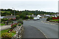
2
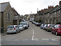
Main Street in Heamoor
Looking southward.
Image: © Peter Wood
Taken: 1 May 2017
0.06 miles
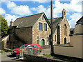
5
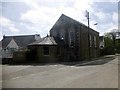
Former Bible Christian Chapel, Heamoor
Now a private dwelling. Flush bracket G1991 can be found on this church.
Image: © Rude Health
Taken: 6 May 2015
0.09 miles
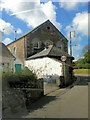
6
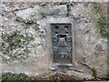
Ordnance Survey Flush Bracket G1991
This bracket can be found on the roadside wall of a building in Heamoor. The benchmark height is recorded as being 50.603 metres above sea level.
For more detail see : http://www.bench-marks.org.uk/bm14103
Image: © Peter Wood
Taken: 1 May 2017
0.09 miles
8
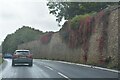
Penzance : Heamoor - A30
Looking along the A30.
Image: © Lewis Clarke
Taken: 28 Sep 2022
0.16 miles
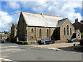
9
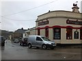
The Sportsman's Arms, Heamoor
An inn on a crossroads in Heamoor, with distinctive architecture
Image: © David Smith
Taken: 21 Mar 2013
0.18 miles
10

On the boundary
1934 boundary marker of the former Borough of Penzance.
Image: © Malcolm Kewn
Taken: 27 Mar 2009
0.19 miles