IMAGES TAKEN NEAR TO
Manor Way, PENZANCE, TR18 3HN
Introduction
This page details the photographs taken nearby to Manor Way, TR18 3HN by members of the Geograph project.
The Geograph project started in 2005 with the aim of publishing, organising and preserving representative images for every square kilometre of Great Britain, Ireland and the Isle of Man.

There are currently over 7.5m images from over14,400 individuals and you can help contribute to the project by visiting https://www.geograph.org.uk
Image Map
Images are licensed for reuse under creativecommons.org/licenses/by-sa/2.0
Notes
- Clicking on the map will re-center to the selected point.
- The higher the marker number, the further away the image location is from the centre of the postcode.
Image Listing (35 Images Found)
Images are licensed for reuse under creativecommons.org/licenses/by-sa/2.0
Image
Details
Distance
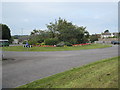
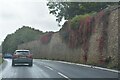
1
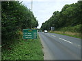
A30 towards Redruth
Looking north east on the outskirts of Penzance.
Image: © JThomas
Taken: 13 Jul 2017
0.04 miles
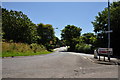
3
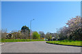
Penzance : The A30
A roundabout on the A30.
Image: © Lewis Clarke
Taken: 21 Apr 2018
0.07 miles

5
Penzance : The A30
A roundabout on the A30.
Image: © Lewis Clarke
Taken: 21 Apr 2018
0.08 miles
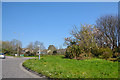
6
Roundabout on the A30 at Heamoor
Penwith District Council's roundabouts are always a blaze of colour.
Image: © Rod Allday
Taken: 17 Sep 2008
0.08 miles
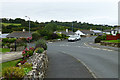
7
Heamoor : Madron Road
From a roundabout at the A30 looking down Madron Road.
Image: © Lewis Clarke
Taken: 2 Jul 2011
0.08 miles
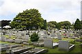
8
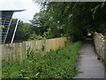
Path by Penwith Campus
Off Manor Way the path between Penwith Campus and Cemetery
Image: © Shaun Ferguson
Taken: 30 May 2014
0.10 miles
10
Penzance : Heamoor - A30
Looking along the A30.
Image: © Lewis Clarke
Taken: 28 Sep 2022
0.12 miles