IMAGES TAKEN NEAR TO
Trevean Road, PENZANCE, TR18 2RT
Introduction
This page details the photographs taken nearby to Trevean Road, TR18 2RT by members of the Geograph project.
The Geograph project started in 2005 with the aim of publishing, organising and preserving representative images for every square kilometre of Great Britain, Ireland and the Isle of Man.

There are currently over 7.5m images from over14,400 individuals and you can help contribute to the project by visiting https://www.geograph.org.uk
Image Map
Images are licensed for reuse under creativecommons.org/licenses/by-sa/2.0
Notes
- Clicking on the map will re-center to the selected point.
- The higher the marker number, the further away the image location is from the centre of the postcode.
Image Listing (96 Images Found)
Images are licensed for reuse under creativecommons.org/licenses/by-sa/2.0
Image
Details
Distance
1
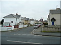
Trevean Road, Penzance
Older-style social housing to the west of the town centre, viewed from Penalverne Drive.
Image: © Jonathan Billinger
Taken: 17 Mar 2010
0.02 miles
2
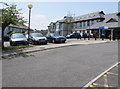
West Cornwall Hospital, Penzance
Main entrance from Penalverne Drive near the corner of Parc Wartha Crescent.
Image: © Jaggery
Taken: 4 Jun 2016
0.10 miles
3
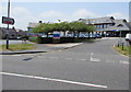
Access road to West Cornwall Hospital, Penzance
From Penalverne Drive towards the main hospital entrance.
Image: © Jaggery
Taken: 4 Jun 2016
0.10 miles
4
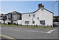
Northern end of Penalverne Drive, Penzance
The St Clare Street junction is on the right.
The black arrow on the sign points left towards the West Cornwall Hospital. http://www.geograph.org.uk/photo/4982957
Image: © Jaggery
Taken: 4 Jun 2016
0.11 miles
5
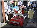
Muffin the Mule
A view looking southeast down Causewayhead, showing a children's ride from a more innocent age, outside the Bear Creek store. Cue all the usual jokes .....
Image: © Phil Williams
Taken: 1 May 2006
0.12 miles
6
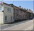
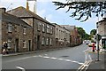
Row of houses, St Clare Street, Penzance
Extending from the corner of Windsor Place on the left.
Image: © Jaggery
Taken: 4 Jun 2016
0.12 miles
7
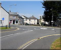
Mini-roundabout in St Clare Street, Penzance
Viewed from the northern end of Penalverne Drive.
Image: © Jaggery
Taken: 4 Jun 2016
0.13 miles
8
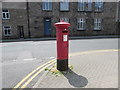
King George V pillarbox and shadow, St Clare Street, Penzance
Located outside St Clare Street post office. http://www.geograph.org.uk/photo/4983008
The GR on the box is short for Georgius Rex, Latin for King George,
in this case King George V who reigned from May 1910-January 1936.
Image: © Jaggery
Taken: 4 Jun 2016
0.13 miles
9
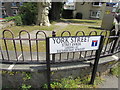
York Street/Stret Evrek name sign, Penzance
The partly bilingual (English/Cornish) name sign is opposite St Clare Street post office. http://www.geograph.org.uk/photo/4983008
No Cornish language version of LEADING TO RICHMOND STREET is shown.
Image: © Jaggery
Taken: 4 Jun 2016
0.13 miles
10
Old Hospital Buildings on Saint Clare Street
These buildings look like they are still used for some things by the hospital but most of the West Cornwall Hospital is housed in new buildings behind these.
Image: © Tony Atkin
Taken: 19 Jul 2007
0.13 miles