IMAGES TAKEN NEAR TO
Churchway, MARAZION, TR17 0DT
Introduction
This page details the photographs taken nearby to Churchway, TR17 0DT by members of the Geograph project.
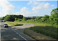
The Geograph project started in 2005 with the aim of publishing, organising and preserving representative images for every square kilometre of Great Britain, Ireland and the Isle of Man.

There are currently over 7.5m images from over14,400 individuals and you can help contribute to the project by visiting https://www.geograph.org.uk
Image Map (Loading...)


Getting Data...Please wait
Leaflet Map data © OpenStreetMap
Images are licensed for reuse under creativecommons.org/licenses/by-sa/2.0
Notes
- Clicking on the map will re-center to the selected point.
- The higher the marker number, the further away the image location is from the centre of the postcode.
Image Listing (36 Images Found)
Images are licensed for reuse under creativecommons.org/licenses/by-sa/2.0
Image
Details
Distance
1

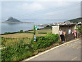
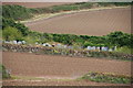
Marazion : Turnpike Road
A road heads down into the town of Marazion.
Image: © Lewis Clarke
Taken: 21 Apr 2018
0.11 miles
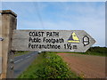
3
Cornwall : Footpath
The South West Coast Path heads down to the coastline.
Image: © Lewis Clarke
Taken: 21 Apr 2018
0.12 miles
4
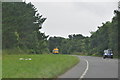
Cornwall : The A394
Looking along the A394 as it heads through Cornwall.
Image: © Lewis Clarke
Taken: 16 Jul 2015
0.13 miles
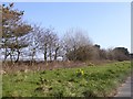
6
Cemetery in Marazion
It is surrounded by fields of winter cauliflowers.
Image: © Bill Boaden
Taken: 7 Jul 2014
0.13 miles
7
Daffodils on the wide verge of the A394 near Goldsithney
Image: © David Smith
Taken: 14 Mar 2016
0.14 miles
8
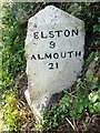
Old Milestone on the Turnpike Road, east of Marazion
Carved stone post by the UC road, in parish of MARAZION (PENWITH District), Turnpike Road, East end of Marazion, in overgrown hedge, East of walled cemetery, on South side of road. Helston facets, erected by the Helston turnpike trust in the 19th century.
Inscription reads:-
: PENZ(ANCE) / 4 / LANDS END / 14 : : (H)ELSTON / 9 / (F)ALMOUTH / 21 :
Grade II listed.
List Entry Number: 1327579 https://historicengland.org.uk/listing/the-list/list-entry/1327579
Milestone Society National ID: CW_PZHL04.
Image: © Rosy Hanns
Taken: 27 Jun 2019
0.14 miles
9
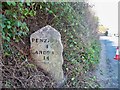
Old Milestone on the Turnpike Road, east of Marazion
Carved stone post by the UC road, in parish of MARAZION (PENWITH District), Turnpike Road, East end of Marazion, in overgrown hedge, East of walled cemetery, on South side of road. Helston facets, erected by the Helston turnpike trust in the 19th century.
Inscription reads:-
: PENZANCE / 4 MILES / LAND'S END / 14 : : HELSTON / 9 / FALMOUTH / 21 :
Grade II Listed. List Entry Number: 1327579
https://historicengland.org.uk/listing/the-list/list-entry/1327579
Milestone Society National ID: CW_PZHL04.
Image: © Ian Thompson
Taken: 15 Apr 2010
0.15 miles
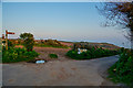
10
A394 Marazion bypass, slip road from Trevennor
Image: © Roy Hughes
Taken: 1 Jul 2021
0.15 miles