IMAGES TAKEN NEAR TO
Turnpike Road, MARAZION, TR17 0DQ
Introduction
This page details the photographs taken nearby to Turnpike Road, TR17 0DQ by members of the Geograph project.
The Geograph project started in 2005 with the aim of publishing, organising and preserving representative images for every square kilometre of Great Britain, Ireland and the Isle of Man.

There are currently over 7.5m images from over14,400 individuals and you can help contribute to the project by visiting https://www.geograph.org.uk
Image Map
Images are licensed for reuse under creativecommons.org/licenses/by-sa/2.0
Notes
- Clicking on the map will re-center to the selected point.
- The higher the marker number, the further away the image location is from the centre of the postcode.
Image Listing (47 Images Found)
Images are licensed for reuse under creativecommons.org/licenses/by-sa/2.0
Image
Details
Distance
1
Marazion - Turnpike Road turning to Chymorvah Hotel
Image: © James Emmans
Taken: 29 May 2016
0.07 miles
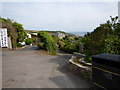
2
Turnpike Road at Marazion
Looking eastward.
Image: © Peter Wood
Taken: 1 May 2017
0.09 miles
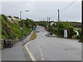
3
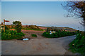
Marazion : Turnpike Road
A road heads down into the town of Marazion.
Image: © Lewis Clarke
Taken: 21 Apr 2018
0.09 miles
4
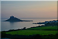
Marazion : Coastal Scenery
St Michael's Mount and surrounding countryside.
Image: © Lewis Clarke
Taken: 21 Apr 2018
0.09 miles
6
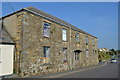
Former artillery drill hall - Turnpike Road
Pre-1900 artillery drill hall with artillery motif similar to St Just.
Image: © John M
Taken: 9 Sep 2014
0.10 miles
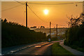
7
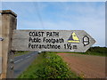
Cornwall : Footpath
The South West Coast Path heads down to the coastline.
Image: © Lewis Clarke
Taken: 21 Apr 2018
0.10 miles
8
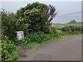
Footpath closed!
The South West Coast Path leaves the lane into the bushes on the left. However, the signs indicate "No legal public access due to very dangerous unstable cliffs". I just came up this way - there did not seem to be an equivalent sign at the other end of the section, but the cliffs are definitely crumbling! See: https://www.geograph.org.uk/photo/6902441
Image: © David Medcalf
Taken: 10 Jun 2021
0.11 miles
9
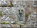
Ordnance Survey Flush Bracket 1811
This bracket can be found on the roadside wall of a building in Turnpike Road, Marazion. The benchmark height is recorded as being 37.757 metres above sea level.
For more detail see : http://www.bench-marks.org.uk/bm2039
Image: © Peter Wood
Taken: 1 May 2017
0.11 miles
10
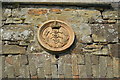
Artillery motif on the former drill hall
Pre 1900 artillery drill hall with artillery motif similar to St Just.
Image: © John M
Taken: 9 Sep 2014
0.11 miles