IMAGES TAKEN NEAR TO
Penstruthal, REDRUTH, TR16 6SX
Introduction
This page details the photographs taken nearby to TR16 6SX by members of the Geograph project.
The Geograph project started in 2005 with the aim of publishing, organising and preserving representative images for every square kilometre of Great Britain, Ireland and the Isle of Man.

There are currently over 7.5m images from over14,400 individuals and you can help contribute to the project by visiting https://www.geograph.org.uk
Image Map (Loading...)


Getting Data...Please wait
Leaflet Map data © OpenStreetMap
Images are licensed for reuse under creativecommons.org/licenses/by-sa/2.0
Notes
- Clicking on the map will re-center to the selected point.
- The higher the marker number, the further away the image location is from the centre of the postcode.
Image Listing (3 Images Found)
Images are licensed for reuse under creativecommons.org/licenses/by-sa/2.0
Image
Details
Distance
2
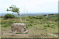
Capped mine shaft at Buller Downs
Probably part of the Wheal Buller mine complex, one of the greatest copper mines in Cornwall.
Image: © Rod Allday
Taken: 8 Jul 2010
0.17 miles
3
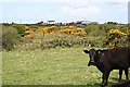
Farmland on Buller Downs
The land here is almost all grazing for cattle. Areas of land contaminated with mine waste are left for the gorse and brambles.
Image: © Tony Atkin
Taken: 7 May 2006
0.24 miles