IMAGES TAKEN NEAR TO
Lower Carnkie, REDRUTH, TR16 6SP
Introduction
This page details the photographs taken nearby to TR16 6SP by members of the Geograph project.
The Geograph project started in 2005 with the aim of publishing, organising and preserving representative images for every square kilometre of Great Britain, Ireland and the Isle of Man.

There are currently over 7.5m images from over14,400 individuals and you can help contribute to the project by visiting https://www.geograph.org.uk
Image Map
Images are licensed for reuse under creativecommons.org/licenses/by-sa/2.0
Notes
- Clicking on the map will re-center to the selected point.
- The higher the marker number, the further away the image location is from the centre of the postcode.
Image Listing (48 Images Found)
Images are licensed for reuse under creativecommons.org/licenses/by-sa/2.0
Image
Details
Distance
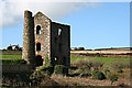
1
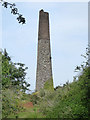
Wheal Basset - Miner's Shaft chimney
This served a winding engine installed in 1890. The mine closed by 1918. There is a very overgrown winding engine house out of sight to the left.
Image: © Chris Allen
Taken: 16 May 2019
0.06 miles
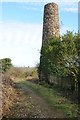
2
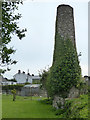
Wheal Basset - stubby chimney
This is on the edge of somebody's garden and is now of uncertain original function. It is close to a small engine house that drove a pump for recirculating water to the dressing floors and may have operated a rock crusher also.
Image: © Chris Allen
Taken: 16 May 2019
0.06 miles
3

Wheal Basset - chimneys
The closer chimney is shorter and served an uncertain function. The further chimney is quite a bit taller and served the boiler house for the Miner's Shaft winding engine.
Image: © Chris Allen
Taken: 16 May 2019
0.07 miles
4

Wheal Basset Stamps
Part of the great flat lode, this image is of the old Wheal Basset Stamps buildings where mineral ore was extracted from the adjacent mines. Whereupon the ore is crushed, stamped, extracting and refining the raw minerals.
In the image, the foreground is the old mine workings, the mine workings on the horizon and to the right is also part of the Basset mines (image of which, see Image)
The green field's to the left is the Wheal Buller and currently riding stables
Image: © Pete Cruse
Taken: 4 Dec 2021
0.07 miles
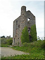
5
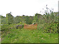
Wheal Basset - ruinous engine house
It took me a while to recognise this overgrown ruin as a former engine house. This housed a horizontal duplex winding engine with 24 inch cylinders that drew from Miner's Shaft. The engine was erected in 1890 and took over the function of the whim engine at Lyle's shaft. The chimney survives out of shot to the right.
Image: © Chris Allen
Taken: 16 May 2019
0.07 miles
6
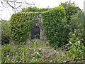
Wheal Basset - small engine house
This diminutive house was not for the main pumping or whim engines but housed a small engine used to recirculate water to the dressing floors. It is close to a stubby chimney on the other side of the path. The purpose of this chimney is now unknown.
Image: © Chris Allen
Taken: 16 May 2019
0.07 miles
8
Chimney at Carnkie
Chimney among former mine buildings at Carnkie.
Image: © Philip Halling
Taken: 2 Jan 2014
0.08 miles
9
Wheal Basset - Lyle's Shaft pumping engine
Listed Grade II. Built to house an 80" pumping engine designed by John Hocking and built by Harvey & Co of Hayle. The engine was erected on this shaft in 1879 and was the third to have occupied this site. The engine house had boiler houses on both side, which was unusual. In the background is the stamps engine house for West Wheal Basset. The Lyle's Shaft whim engine house is out of sight to the left.
Image: © Chris Allen
Taken: 16 May 2019
0.09 miles
10
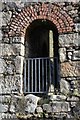
Detail of former engine house
Detail of former engine house at Carnkie.
Image: © Philip Halling
Taken: 2 Jan 2014
0.09 miles