IMAGES TAKEN NEAR TO
Deep Lane, REDRUTH, TR16 6RE
Introduction
This page details the photographs taken nearby to Deep Lane, TR16 6RE by members of the Geograph project.
The Geograph project started in 2005 with the aim of publishing, organising and preserving representative images for every square kilometre of Great Britain, Ireland and the Isle of Man.

There are currently over 7.5m images from over14,400 individuals and you can help contribute to the project by visiting https://www.geograph.org.uk
Image Map
Images are licensed for reuse under creativecommons.org/licenses/by-sa/2.0
Notes
- Clicking on the map will re-center to the selected point.
- The higher the marker number, the further away the image location is from the centre of the postcode.
Image Listing (3 Images Found)
Images are licensed for reuse under creativecommons.org/licenses/by-sa/2.0
Image
Details
Distance
1
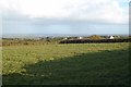
Scattered houses and farmland on Buller Downs
Scattered houses and farmland on Buller Downs to the south of Redruth.
Image: © Philip Halling
Taken: 7 Nov 2017
0.17 miles
2
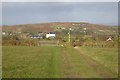
Buller Downs
Farmland and scattered dwellings in Buller Downs.
Image: © Philip Halling
Taken: 7 Nov 2017
0.24 miles
3
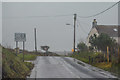
Redruth : Buller Hill B3297
Looking along Buller Hill.
Image: © Lewis Clarke
Taken: 18 Dec 2019
0.24 miles