IMAGES TAKEN NEAR TO
Tresamble, REDRUTH, TR16 6BQ
Introduction
This page details the photographs taken nearby to Tresamble, TR16 6BQ by members of the Geograph project.
The Geograph project started in 2005 with the aim of publishing, organising and preserving representative images for every square kilometre of Great Britain, Ireland and the Isle of Man.

There are currently over 7.5m images from over14,400 individuals and you can help contribute to the project by visiting https://www.geograph.org.uk
Image Map (Loading...)


Getting Data...Please wait
Leaflet Map data © OpenStreetMap
Images are licensed for reuse under creativecommons.org/licenses/by-sa/2.0
Notes
- Clicking on the map will re-center to the selected point.
- The higher the marker number, the further away the image location is from the centre of the postcode.
Image Listing (4 Images Found)
Images are licensed for reuse under creativecommons.org/licenses/by-sa/2.0
Image
Details
Distance
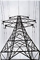
1
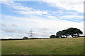
Field and overhead power lines at Tresamble
Image: © Rod Allday
Taken: 8 Jul 2010
0.17 miles
3
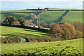
Pasture, Gwennap
A footpath descends to the gate on its way across fields to the east of South Tresamble.
Image: © Andrew Smith
Taken: 7 Dec 2022
0.23 miles
4
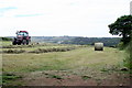
Hay making at Gwennap
The tractor is turning the cut hay to ensure that it dries through before baling.
Image: © Rod Allday
Taken: 8 Jul 2010
0.25 miles