
IMAGES TAKEN NEAR TO
Ting Tang, REDRUTH, TR16 5SF
Introduction
This page details the photographs taken nearby to Ting Tang, TR16 5SF by members of the Geograph project.
The Geograph project started in 2005 with the aim of publishing, organising and preserving representative images for every square kilometre of Great Britain, Ireland and the Isle of Man.

There are currently over 7.5m images from over14,400 individuals and you can help contribute to the project by visiting https://www.geograph.org.uk
Image Map
Images are licensed for reuse under creativecommons.org/licenses/by-sa/2.0
Notes
- Clicking on the map will re-center to the selected point.
- The higher the marker number, the further away the image location is from the centre of the postcode.
Image Listing (17 Images Found)
Images are licensed for reuse under creativecommons.org/licenses/by-sa/2.0
Image
Details
Distance

2
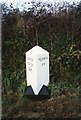
Old Milestone by the B3298, south of Carharrack
Carved stone post by the B3298, in parish of CARHARRACK (KERRIER District), South of St Day, near Gwennap Pit turn, by 30 mph sign, on West side of road. Erected by the Local Highways Board in the 19th century.
Inscription reads:-
: SCORRIER / STATION / 2½ M : : PENRYN / 6 M :
Grade II Listed. List Entry Number: 1328132
https://historicengland.org.uk/listing/the-list/list-entry/1328132
Milestone Society National ID: CW_PRSS06.
Image: © Ian Thompson
Taken: 10 Dec 2017
0.07 miles
3
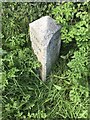
Old Milestone by the B3298, south of Carharrack
Carved stone post by the B3298, in parish of CARHARRACK (KERRIER District), South of St Day, near Gwennap Pit turn, by 30 mph sign, on West side of road. Erected by the Local Highways Board in the 19th century.
Inscription reads:-
: SCORRIER / STATION / 2½ M : : PENRYN / 6 M :
Grade II Listed. List Entry Number: 1328132
https://historicengland.org.uk/listing/the-list/list-entry/1328132
Milestone Society National ID: CW_PRSS06.
Image: © P Barnett
Taken: 3 May 2024
0.07 miles
4
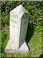
Old Milestone by the B3298, south of Carharrack
Carved stone post by the B3298, in parish of CARHARRACK (KERRIER District), South of St Day, near Gwennap Pit turn, by 30 mph sign, on West side of road. Erected by the Local Highways Board in the 19th century.
Inscription reads:-
: SCORRIER / STATION / 2½ M : : PENRYN / 6 M :
Grade II listed.
List Entry Number: 1328132 https://historicengland.org.uk/listing/the-list/list-entry/1328132
Milestone Society National ID: CW_PRSS06.
Image: © Rosy Hanns
Taken: 3 May 2019
0.07 miles
5
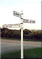
Old Direction Sign - Signpost by the B3298, Carharrack
Pyramid spear finial - 3 arms; Cornwall CC iron spear by the B3298, in parish of Carharrack (Kerrier District), Carharrack village, Trevarth turn.
Surveyed
Milestone Society National ID: CW_SW7341
Image: © Milestone Society
Taken: Unknown
0.12 miles
6

Road and bridleway entering Carharrack
Shown as separate on the map, but not on the ground.
Image: © David Medcalf
Taken: 16 Apr 2026
0.13 miles
7
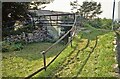
Footbridge over the former Redruth & Chasewater railway. 1824-1915
Apart from most of the route of this unique little line, built by John Taylor to mainly serve his great copper mines along its course (with the odd run of stone sleeper blocks still in evidence) there remains, tucked away in Carharrack village through which it passed, a little footbridge over the former formation. Now a Grade II listed structure, this fairly unimposing small relic has recently been refurbished by the local council.
Image: © Richard Bird
Taken: 22 Jul 1991
0.14 miles
8
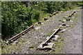
Old Railway Track
Sections of the track of the Redruth and Chacewater Railway. The track was not laid on wooden sleepers, but rather on granite "chairs" set in the ground. In this shot there are actually two generations of track. Nearer the camera the track is the original style, from when the wagons were horse-drawn. Further from the camera the track is of a heavier cross section, installed when steam locomotives replaced horses.
Image: © Graham Loveland
Taken: 4 Jul 2013
0.15 miles
9
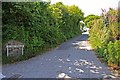
Hillside Terrace, from the junction with Pennance Road
Image: © Graham Loveland
Taken: 4 Jul 2013
0.18 miles
10

Cottages on Church Street, Carharrack
Image: © David Medcalf
Taken: 16 Apr 2026
0.18 miles