IMAGES TAKEN NEAR TO
Poldory, REDRUTH, TR16 5HS
Introduction
This page details the photographs taken nearby to Poldory, TR16 5HS by members of the Geograph project.
The Geograph project started in 2005 with the aim of publishing, organising and preserving representative images for every square kilometre of Great Britain, Ireland and the Isle of Man.

There are currently over 7.5m images from over14,400 individuals and you can help contribute to the project by visiting https://www.geograph.org.uk
Image Map
Images are licensed for reuse under creativecommons.org/licenses/by-sa/2.0
Notes
- Clicking on the map will re-center to the selected point.
- The higher the marker number, the further away the image location is from the centre of the postcode.
Image Listing (1 Images Found)
Images are licensed for reuse under creativecommons.org/licenses/by-sa/2.0
Image
Details
Distance
1
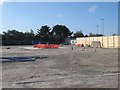
United Downs geothermal well
I was very disappointed that my holiday came after the drilling rig had been dismantled and taken away to its next assignment. However, the well heads (injection and production) can be seen on the pad. A geothermal power station is envisaged, using water circulated through the Porthtowan Fracture Zone at more than 5km depth. The bottom hole temperature should be 190 degrees C. Unlike previous geothermal prospecting in Cornwall, this well is in slate and not granite, but the whole area has an unusually high thermal conductivity.
Image: © Jonathan Wilkins
Taken: 20 Sep 2019
0.19 miles