IMAGES TAKEN NEAR TO
Trefula, REDRUTH, TR16 5ET
Introduction
This page details the photographs taken nearby to TR16 5ET by members of the Geograph project.
The Geograph project started in 2005 with the aim of publishing, organising and preserving representative images for every square kilometre of Great Britain, Ireland and the Isle of Man.

There are currently over 7.5m images from over14,400 individuals and you can help contribute to the project by visiting https://www.geograph.org.uk
Image Map
Images are licensed for reuse under creativecommons.org/licenses/by-sa/2.0
Notes
- Clicking on the map will re-center to the selected point.
- The higher the marker number, the further away the image location is from the centre of the postcode.
Image Listing (6 Images Found)
Images are licensed for reuse under creativecommons.org/licenses/by-sa/2.0
Image
Details
Distance
1
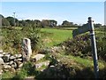
Footpath to Trefula
An antique, stone-built stile is overlooked by a more modern footpath sign.
Image: © Jonathan Wilkins
Taken: 15 Sep 2019
0.08 miles
2
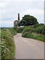
Minor road at St Aubyn Farm
The engine house in the distance is the pump engine house of St Aubyn Mine http://www.imagesofengland.org.uk/Details/Default.aspx?id=66918&mode=adv.
Image: © Rod Allday
Taken: 9 Jul 2010
0.15 miles
3
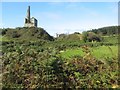
St.Aubyn United Mine
Waste heaps are unusually-well vegetated, but surmounted by an iconic engine house.
Image: © Jonathan Wilkins
Taken: 15 Sep 2019
0.15 miles
4
St Aubyn Farm and engine house
The engine house is the pump engine house of St Aubyn Mine.
Image: © Rod Allday
Taken: 9 Jul 2010
0.18 miles
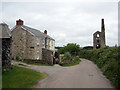
5
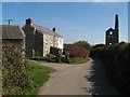
St.Aubyn Farm
Looking along the lane to Ninnis, with the farm on one side of the road and the engine house and chimney on the other.
Image: © Jonathan Wilkins
Taken: 15 Sep 2019
0.18 miles
6
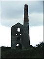
St Aubyn Union Mine, nr St. Day
Remains of the engine house of one of many cornish tin mines.
Image: © Gwyn Jones
Taken: 5 Dec 2005
0.24 miles