IMAGES TAKEN NEAR TO
Mawla Lane End, REDRUTH, TR16 5DN
Introduction
This page details the photographs taken nearby to TR16 5DN by members of the Geograph project.
The Geograph project started in 2005 with the aim of publishing, organising and preserving representative images for every square kilometre of Great Britain, Ireland and the Isle of Man.

There are currently over 7.5m images from over14,400 individuals and you can help contribute to the project by visiting https://www.geograph.org.uk
Image Map
Images are licensed for reuse under creativecommons.org/licenses/by-sa/2.0
Notes
- Clicking on the map will re-center to the selected point.
- The higher the marker number, the further away the image location is from the centre of the postcode.
Image Listing (10 Images Found)
Images are licensed for reuse under creativecommons.org/licenses/by-sa/2.0
Image
Details
Distance
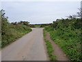
5
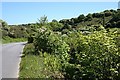
The Valley Floor
Abundant valley floor vegetation along the roadside.
Image: © Tony Atkin
Taken: 2 Jun 2006
0.15 miles
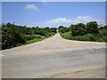
6
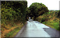
A rainy day
A narrow wet Cornish lane at Mawla north of Redruth.
Image: © Robert Ashby
Taken: 17 Aug 2014
0.19 miles
8
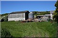
Cottages and hill, Manor Parsley
A row of cottages below the farm, which lies on a steep hill to Mount Hawke.
Image: © Jonathan Wilkins
Taken: 13 Sep 2019
0.21 miles
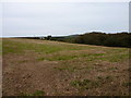
9
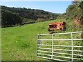
Pasture at Manor Parsley
Having spent all morning looking at mine waste, I thought to redress the balance and show some verdure. For all of its mining history, the upper valley is pretty with fine fields and woods.
Image: © Jonathan Wilkins
Taken: 13 Sep 2019
0.21 miles
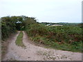
10
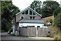
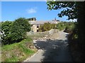
Minor road
House for sale on a lane at Manor Parsley.
Image: © Robert Ashby
Taken: 17 Aug 2014
0.25 miles