IMAGES TAKEN NEAR TO
Radnor Road, REDRUTH, TR16 4AU
Introduction
This page details the photographs taken nearby to Radnor Road, TR16 4AU by members of the Geograph project.
The Geograph project started in 2005 with the aim of publishing, organising and preserving representative images for every square kilometre of Great Britain, Ireland and the Isle of Man.

There are currently over 7.5m images from over14,400 individuals and you can help contribute to the project by visiting https://www.geograph.org.uk
Image Map
Images are licensed for reuse under creativecommons.org/licenses/by-sa/2.0
Notes
- Clicking on the map will re-center to the selected point.
- The higher the marker number, the further away the image location is from the centre of the postcode.
Image Listing (20 Images Found)
Images are licensed for reuse under creativecommons.org/licenses/by-sa/2.0
Image
Details
Distance
1
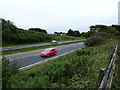
Traffic on the A30
The main A30 dual carriageway near Radnor. A fast road; no place to be cycling on a dull evening.
Image: © Richard Law
Taken: 16 Sep 2012
0.07 miles
3
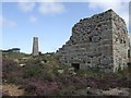
Calciners at Wheal Peevor
The chimney and flue were used to heat the dressed tin ore to remove arsenic and sulphur.
The mine was at its peak in 1872-1888 and was briefly re-opened 1911-1918. It is now preserved as part of the Cornish Mining World Heritage Site by Kerrier District Council and Cornwall County Council.
Image: © John M
Taken: 7 Sep 2008
0.11 miles

5
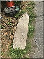
Old Boundary Marker in Treleigh
Boundary Marker on the north side of a side road to the A3047 now passing St Stephen's church and Treleigh primary school. Redruth parish. Inscribed TR. The stone has an unknown function.
Milestone Society National ID: CW_REDRU21bm
Image: © P Barnett
Taken: 20 Jul 2023
0.15 miles
6
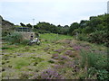
Capped shaft at Wheal Peevor
An unnamed adit shaft of the Wheal Peevor mine, capped by the council in 2005. By (the highly unscientific method of) dropping a stone down it, I deduced that it was too deep to want to fall down, so they did the right thing by capping it off.
Image: © Richard Law
Taken: 16 Sep 2012
0.17 miles
8
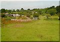
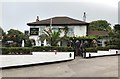
Farm at Wheal Prussia
On the eastern outskirts of Redruth is this smallholding near the former Wheal Prussia.
This photo was taken from the 1158 Penzance to London Paddington train, having left Redruth at 1231.
Image: © Graham Horn
Taken: 9 Jul 2011
0.19 miles