IMAGES TAKEN NEAR TO
Park Bottom, REDRUTH, TR15 3XT
Introduction
This page details the photographs taken nearby to TR15 3XT by members of the Geograph project.
The Geograph project started in 2005 with the aim of publishing, organising and preserving representative images for every square kilometre of Great Britain, Ireland and the Isle of Man.

There are currently over 7.5m images from over14,400 individuals and you can help contribute to the project by visiting https://www.geograph.org.uk
Image Map
Images are licensed for reuse under creativecommons.org/licenses/by-sa/2.0
Notes
- Clicking on the map will re-center to the selected point.
- The higher the marker number, the further away the image location is from the centre of the postcode.
Image Listing (9 Images Found)
Images are licensed for reuse under creativecommons.org/licenses/by-sa/2.0
Image
Details
Distance
1
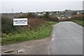
Approaching Park Bottom
The sign gives the name of this settlement in both English and Cornish.
Image: © Tony Atkin
Taken: 30 Dec 2005
0.08 miles
2
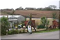
Farm and Garden Centre
In the foreground a small garden centre and on the hilltop behind, Park Bottom Farm.
Image: © Tony Atkin
Taken: 30 Dec 2005
0.09 miles
3
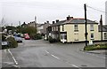
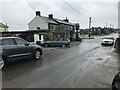
Park Bottom
At one time this was just a crossroads hamlet but is now part of the large area of suburban housing to the north of Redruth, centred on Illogan.
Image: © Tony Atkin
Taken: 30 Dec 2005
0.19 miles
6
Modern boundary stone - Carn Brea parish
Image: © Paul Barnett
Taken: 11 Apr 2023
0.22 miles
7
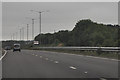
Cornwall : The A30
The A30 as it approached Camborne.
Image: © Lewis Clarke
Taken: 13 Jul 2015
0.24 miles
8
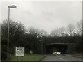
The A30 east, on the Redruth Camborne bypass
Image: © Roy Hughes
Taken: 1 Jul 2022
0.24 miles
9
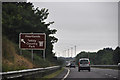
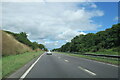
Cornwall : The A30
The A30 passing a sign for Heartlands and Tehidy Country Park.
Image: © Lewis Clarke
Taken: 13 Jul 2015
0.25 miles