IMAGES TAKEN NEAR TO
Old Portreath Road, REDRUTH, TR15 3TJ
Introduction
This page details the photographs taken nearby to Old Portreath Road, TR15 3TJ by members of the Geograph project.
The Geograph project started in 2005 with the aim of publishing, organising and preserving representative images for every square kilometre of Great Britain, Ireland and the Isle of Man.

There are currently over 7.5m images from over14,400 individuals and you can help contribute to the project by visiting https://www.geograph.org.uk
Image Map
Images are licensed for reuse under creativecommons.org/licenses/by-sa/2.0
Notes
- Clicking on the map will re-center to the selected point.
- The higher the marker number, the further away the image location is from the centre of the postcode.
Image Listing (22 Images Found)
Images are licensed for reuse under creativecommons.org/licenses/by-sa/2.0
Image
Details
Distance
1
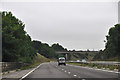
Cornwall : The A30
Looking along the A30 road through Cornwall and passing Redruth.
Image: © Lewis Clarke
Taken: 13 Jul 2015
0.07 miles
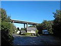
2
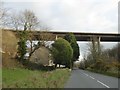
A30 bridge over New Portreath Road, B3300
Image: © David Smith
Taken: 11 Mar 2016
0.07 miles
3
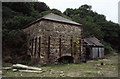
Brunton's arsenic calciner
Just north of the A30 on the road to Tolgus Tin.
I hope I've got the location right. It's not easy to locate from secondary sources and I took it before Geograph featured on my radar.
Image: © Chris Allen
Taken: Unknown
0.07 miles
4
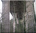
Underneath the Viaduct
This modern viaduct spans a deep valley and carries the main A30 road.
Image: © Tony Atkin
Taken: 31 Dec 2005
0.08 miles
6
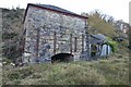
Brunton's Arsenic Calcining Kiln
This is a nice, mostly complete calcining kiln. A waterwheel provided power for the gearing sited in the front opening. A table rotated five times an hour heating the cassiterite ore to 600 degrees celsius. The cassiterite (tin ore) was collected off the table, the arsenic was condensed in a flue to the left and scraped off.
Image: © Ashley Dace
Taken: 24 Nov 2013
0.11 miles
7
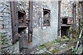
Brunton's Arsenic Calcining Kiln
This is a nice, mostly complete calcining kiln. A waterwheel provided power for the gearing. A table rotated five times an hour heating the cassiterite ore to 600 degrees celsius. The cassiterite (tin ore) was collected off the table, the arsenic was condensed in a flue and scraped off.
This view shows the coal grates.
Image: © Ashley Dace
Taken: 24 Nov 2013
0.13 miles
8
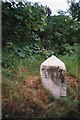
Old Milestone by the B3300, north of Redruth
Carved stone post by the B3300, in parish of REDRUTH (KERRIER District), New Portreath Road, Gilberts Combe, on the verge. Traffic damage, on West side of road. Erected by the Local Highways Board in the 19th century.
Inscription reads:-
: PORTREATH / 3.MILES : : REDRUTH / T.C. / 1.MILE :
Grade II Listed. List Entry Number: 1309870
https://historicengland.org.uk/listing/the-list/list-entry/1309870
Milestone Society National ID: CW_PRRR03.
Image: © Ian Thompson
Taken: 10 Dec 2017
0.13 miles
9
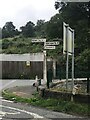
Direction Sign – Signpost on the B3300 in Redruth
Located on the north side of the junction of the B3300 Tolgus Place/New Portreath Road and Old Portreath Road in Redruth parish. 3 arms and pyramid spear finial. See https://www.geograph.org.uk/photo/6068543 for an older photo.
Milestone Society National ID: CW_SW6942
Image: © P Barnett
Taken: 11 Jul 2023
0.13 miles
10

Old Direction Sign - Signpost by the B3300, Tolgus Mount, Redruth parish
Pyramid spear finial - Plastic letters falling off one arm; Cornwall CC iron spear by the B3300, in parish of Redruth (Kerrier District), Tolgus Mount, at Y-junction of New and Old Portreath Roads.
Background cottage has been demolished now.
Cornwall & Scilly HER.
HER Number: MCO54578 https://www.heritagegateway.org.uk/Gateway/Results_Single.aspx?uid=MCO54578&resourceID=1020
Surveyed
Milestone Society National ID: CW_SW6942
Image: © Milestone Society
Taken: Unknown
0.13 miles