IMAGES TAKEN NEAR TO
West Tolgus, REDRUTH, TR15 3TE
Introduction
This page details the photographs taken nearby to TR15 3TE by members of the Geograph project.
The Geograph project started in 2005 with the aim of publishing, organising and preserving representative images for every square kilometre of Great Britain, Ireland and the Isle of Man.

There are currently over 7.5m images from over14,400 individuals and you can help contribute to the project by visiting https://www.geograph.org.uk
Image Map
Images are licensed for reuse under creativecommons.org/licenses/by-sa/2.0
Notes
- Clicking on the map will re-center to the selected point.
- The higher the marker number, the further away the image location is from the centre of the postcode.
Image Listing (16 Images Found)
Images are licensed for reuse under creativecommons.org/licenses/by-sa/2.0
Image
Details
Distance

5
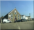
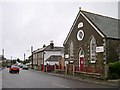
Grapevine Community Church at Illogan
Grapevine Community Church developed from a house church in 1995 and consists of people from a wide range of differing backgrounds http://www.grapevinecommunitychurch.org/index.html.
Image: © Rod Allday
Taken: 22 Oct 2010
0.09 miles
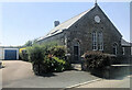
7
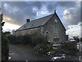
Primitive Methodist Sunday school 1890
Image: © Paul Barnett
Taken: 17 Jan 2023
0.10 miles
8
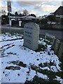
Modern parish boundary stone Carn Brea
Image: © Paul Barnett
Taken: 17 Jan 2023
0.11 miles
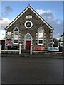
9
1920 Institute
In memory of the Tangye family
Image: © Paul Barnett
Taken: 17 Jan 2023
0.15 miles
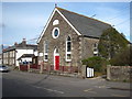
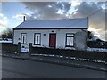
10
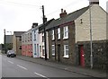
Housing Terrace on the Illogan Road
The nearest house is built in a typical style for this area with granite blocks on the corners and around the windows and door, the rest being built of local shale which is an orange-brown colour, having been baked in the ground by being close to the granite intrusion.
Image: © Tony Atkin
Taken: 30 Dec 2005
0.15 miles