IMAGES TAKEN NEAR TO
Moorfield Road, REDRUTH, TR15 3QB
Introduction
This page details the photographs taken nearby to Moorfield Road, TR15 3QB by members of the Geograph project.
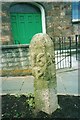
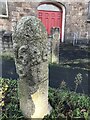
The Geograph project started in 2005 with the aim of publishing, organising and preserving representative images for every square kilometre of Great Britain, Ireland and the Isle of Man.

There are currently over 7.5m images from over14,400 individuals and you can help contribute to the project by visiting https://www.geograph.org.uk
Image Map
Images are licensed for reuse under creativecommons.org/licenses/by-sa/2.0
Notes
- Clicking on the map will re-center to the selected point.
- The higher the marker number, the further away the image location is from the centre of the postcode.
Image Listing (61 Images Found)
Images are licensed for reuse under creativecommons.org/licenses/by-sa/2.0
Image
Details
Distance
1
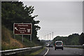
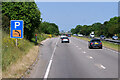
Cornwall : The A30
The A30 passing a sign for Heartlands and Tehidy Country Park.
Image: © Lewis Clarke
Taken: 13 Jul 2015
0.18 miles
2
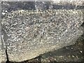
Benchmark on the left of Light and Life church door, Fore Street, Pool
Faded due to weathering
Image: © Ben Chmark
Taken: 26 Oct 2023
0.18 miles
3
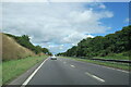
The A30 east, on the Redruth Camborne bypass
Image: © Roy Hughes
Taken: 1 Jul 2022
0.19 miles
4
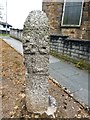
Old Milestone by the former A3047, Carn Brea parish
Carved stone post by the A3047, in parish of CARN BREA (KERRIER District), Illogan Highway, by Pool chapel, by MacSalvors, on pavement, at corner of flower bed, on South side of road. Erected by the parish in the 18th century.
Inscription reads:-
: 16 / P : : 26 / L :
Grade II listed.
List Entry Number: 1396217 https://historicengland.org.uk/listing/the-list/list-entry/1396217
Milestone Society National ID: CW_PZL16
Image: © Rosy Hanns
Taken: 1 Jun 2019
0.19 miles
5
Old Milestone by the former A3047, Carn Brea parish
Carved stone post by the A3047, in parish of CARN BREA (KERRIER District), Illogan Highway, by Pool chapel, by MacSalvors, on pavement, at corner of flower bed, on South side of road. Erected by the parish in the 18th century.
Inscription reads:-
: 16 / P : : 26 / L :
Listed. List Entry Number: 1396217
https://historicengland.org.uk/listing/the-list/list-entry/1396217
Milestone Society National ID: CW_PZL16.
Image: © Ian Thompson
Taken: 10 Dec 2017
0.19 miles
6
Old Milestone by the former A3047, Carn Brea parish
Carved stone post by the A3047, in parish of CARN BREA (KERRIER District), Illogan Highway, by Pool chapel, by MacSalvors, on pavement, at corner of flower bed, on South side of road. Erected by the parish in the 17th century.
Inscription reads:-
: 16 / P : : 26 / L :
Listed. List Entry Number: 1396217
Milestone Society National ID: CW_PZL16.
Image: © Paul Barnett
Taken: 2 Dec 2022
0.19 miles
7
Layby on the eastbound A30 between Camborne and Redruth
Image: © David Dixon
Taken: 6 Jun 2023
0.19 miles
10
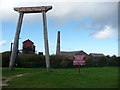
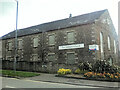
Cornish Mines & Engines Discovery Centre, Camborne
A large site incorporating engine house, museum and visitor centre, audio-visual displays and staffed by helpful assistants. Operated by the National Trust and in a process of being upgraded. The site is almost hidden behind a Morrison's supermarket.
Image: © Jeremy Bolwell
Taken: 6 Oct 2010
0.20 miles