
IMAGES TAKEN NEAR TO
Agar Crescent, REDRUTH, TR15 3NF
Introduction
This page details the photographs taken nearby to Agar Crescent, TR15 3NF by members of the Geograph project.
The Geograph project started in 2005 with the aim of publishing, organising and preserving representative images for every square kilometre of Great Britain, Ireland and the Isle of Man.

There are currently over 7.5m images from over14,400 individuals and you can help contribute to the project by visiting https://www.geograph.org.uk
Image Map
Images are licensed for reuse under creativecommons.org/licenses/by-sa/2.0
Notes
- Clicking on the map will re-center to the selected point.
- The higher the marker number, the further away the image location is from the centre of the postcode.
Image Listing (78 Images Found)
Images are licensed for reuse under creativecommons.org/licenses/by-sa/2.0
Image
Details
Distance
1
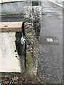
Old guide stone beside Agar Road, Illogan Highway
The guide stone is being used as a gatepost and is positioned on the North side of the road outside number 96/98 Agar Road. Just west of Wheal Fortune Lane and the Railway Inn in Carn Brea parish (Kerrier district).
Inscription reads:-
TBV / 5½ / HAYL / 8 / LAND’S END / 33 / POOL / 2 / TRURO / 15
Benchmark cut at the foot of the post
Milestone Society National ID: CW_POO03
Image: © P Barnett
Taken: 26 Oct 2023
0.10 miles
2
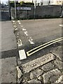
Old Boundary Marker on Agar Road, Illogan Highway
Boundary Marker lying flat on the northeast side of the junction of Wheal Fortune Lane and Agar Road, next to 86 Agar Road. Carn Brea parish. Inscribed B / 8. Thought to mark the boundary of a mine.
Milestone Society National ID: CW_CARNB07em
Image: © Paul Barnett
Taken: 1 Dec 2022
0.11 miles
3
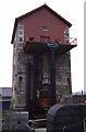
Taylor's Shaft, Pool
90" Cornish beam pumping engine preserved by the National Trust. It is paired with the nearby winding engine that has also been featured in this square. I think both are major features in this square and should be illustrated.
Image: © Chris Allen
Taken: Unknown
0.11 miles
4

Illogan Highway - Agar Road
Agar Road, one of the routes between Redruth and Camborne.
Image: © Pete Cruse
Taken: 25 Feb 2025
0.11 miles
5
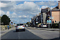
The A3047
Agar Road, Redruth, going East.
Image: © Robert Ashby
Taken: 22 Aug 2014
0.12 miles
6
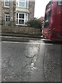
Date stone on Agar Road
Inscription reads:-
1819
Image: © Ben Chmark
Taken: 26 Oct 2023
0.13 miles
7
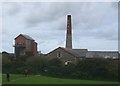
Cornish Mines and Engines Museum
The main museum site lies behind Morrison's Car Park with another engine house nearby.
http://www.theheritagetrail.co.uk/industrial/cornish_engines.htm
Image: © John M
Taken: 7 Sep 2008
0.13 miles
8

EPAL mine - Pool
A view of the chimney from EPAL, a very powerful brand for those wishing to buy arsenic.
Image: © Ashley Dace
Taken: 5 Sep 2012
0.14 miles

10
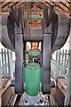
Taylor's Engine - Pool
A head on view of the beam and rod connection with the cylinder top below.
Image: © Ashley Dace
Taken: 20 Sep 2013
0.15 miles