IMAGES TAKEN NEAR TO
Barncoose Terrace, REDRUTH, TR15 3EP
Introduction
This page details the photographs taken nearby to Barncoose Terrace, TR15 3EP by members of the Geograph project.
The Geograph project started in 2005 with the aim of publishing, organising and preserving representative images for every square kilometre of Great Britain, Ireland and the Isle of Man.

There are currently over 7.5m images from over14,400 individuals and you can help contribute to the project by visiting https://www.geograph.org.uk
Image Map
Images are licensed for reuse under creativecommons.org/licenses/by-sa/2.0
Notes
- Clicking on the map will re-center to the selected point.
- The higher the marker number, the further away the image location is from the centre of the postcode.
Image Listing (35 Images Found)
Images are licensed for reuse under creativecommons.org/licenses/by-sa/2.0
Image
Details
Distance
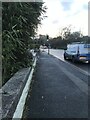
2
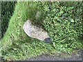
Redruth Boundary stone
Can just about see letter R
Old maps show a benchmark very close to this location which may be on this stone.
BM354.5
Image: © Paul Barnett
Taken: 1 Jan 2023
0.10 miles
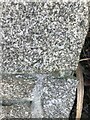
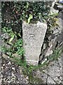
4
Redruth boundary stone
Only a letter R
Tolskithy Lane
Image: © Paul Barnett
Taken: 1 Jan 2023
0.11 miles
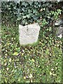
10
Redruth boundary stone
Only a letter R
Tolskithy Lane
Image: © Paul Barnett
Taken: 1 Jan 2023
0.12 miles