IMAGES TAKEN NEAR TO
Mount View, REDRUTH, TR15 3BQ
Introduction
This page details the photographs taken nearby to Mount View, TR15 3BQ by members of the Geograph project.
The Geograph project started in 2005 with the aim of publishing, organising and preserving representative images for every square kilometre of Great Britain, Ireland and the Isle of Man.

There are currently over 7.5m images from over14,400 individuals and you can help contribute to the project by visiting https://www.geograph.org.uk
Image Map
Images are licensed for reuse under creativecommons.org/licenses/by-sa/2.0
Notes
- Clicking on the map will re-center to the selected point.
- The higher the marker number, the further away the image location is from the centre of the postcode.
Image Listing (39 Images Found)
Images are licensed for reuse under creativecommons.org/licenses/by-sa/2.0
Image
Details
Distance
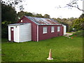
1
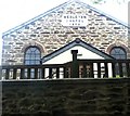
Methodist church
Built 1870 as Wesleyan
Image: © Paul Barnett
Taken: 21 Oct 2015
0.02 miles
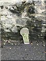
5
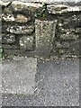
Old Boundary Marker beside Railway Villas, Carn Brea
Mine Boundary Marker set in a stone wall in front of Chyryn on the west side of Railway Villas. Carn Brea parish.
Milestone Society National ID: CW_CARNB13em
Image: © P Barnett
Taken: 3 May 2023
0.06 miles
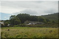
8
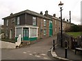
Carn Brea Village
A scene at the crossroads on the western side of the valley, opposite Church Town.
Image: © Derek Harper
Taken: 23 Feb 2009
0.08 miles
10
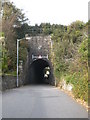
Carn Brea railway bridge
More of a tunnel really, where the road passes through the very high embankment.
Image: © Rod Allday
Taken: 22 Oct 2010
0.11 miles