
IMAGES TAKEN NEAR TO
Bosmeor Park, REDRUTH, TR15 3AQ
Introduction
This page details the photographs taken nearby to Bosmeor Park, TR15 3AQ by members of the Geograph project.
The Geograph project started in 2005 with the aim of publishing, organising and preserving representative images for every square kilometre of Great Britain, Ireland and the Isle of Man.

There are currently over 7.5m images from over14,400 individuals and you can help contribute to the project by visiting https://www.geograph.org.uk
Image Map
Images are licensed for reuse under creativecommons.org/licenses/by-sa/2.0
Notes
- Clicking on the map will re-center to the selected point.
- The higher the marker number, the further away the image location is from the centre of the postcode.
Image Listing (82 Images Found)
Images are licensed for reuse under creativecommons.org/licenses/by-sa/2.0
Image
Details
Distance
1
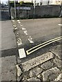
Old Boundary Marker on Agar Road, Illogan Highway
Boundary Marker lying flat on the northeast side of the junction of Wheal Fortune Lane and Agar Road, next to 86 Agar Road. Carn Brea parish. Inscribed B / 8. Thought to mark the boundary of a mine.
Milestone Society National ID: CW_CARNB07em
Image: © Paul Barnett
Taken: 1 Dec 2022
0.08 miles
2
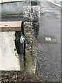
Old guide stone beside Agar Road, Illogan Highway
The guide stone is being used as a gatepost and is positioned on the North side of the road outside number 96/98 Agar Road. Just west of Wheal Fortune Lane and the Railway Inn in Carn Brea parish (Kerrier district).
Inscription reads:-
TBV / 5½ / HAYL / 8 / LAND’S END / 33 / POOL / 2 / TRURO / 15
Benchmark cut at the foot of the post
Milestone Society National ID: CW_POO03
Image: © P Barnett
Taken: 26 Oct 2023
0.09 miles
3

Illogan Highway - Agar Road
Agar Road, one of the routes between Redruth and Camborne.
Image: © Pete Cruse
Taken: 25 Feb 2025
0.09 miles
4
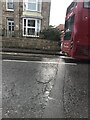
Date stone on Agar Road
Inscription reads:-
1819
Image: © Ben Chmark
Taken: 26 Oct 2023
0.09 miles
5
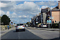
The A3047
Agar Road, Redruth, going East.
Image: © Robert Ashby
Taken: 22 Aug 2014
0.09 miles
6
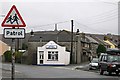
The Corner Chippy
An urban view with Carn Brea hill in the background.
Image: © Tony Atkin
Taken: 30 Dec 2005
0.11 miles
7
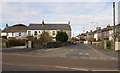
Chili Road, Illogan Highway
Seen across Agar Road. Composer Thomas Merritt (see Image) was an organist in a now-demolished chapel along the road.
Image: © Derek Harper
Taken: 23 Feb 2009
0.11 miles
8
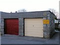
Chili Road garages
Site of former chapel
Image: © Paul Barnett
Taken: 25 Oct 2015
0.11 miles
9
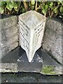
Old Milestone by the A3047, Agar Road
Carved stone post by the A3047, in parish of CARN BREA (KERRIER District), Agar Road, Illogan Highway, by No. 49 and chapel, part of front wall, on South side of road. Erected by the Local Highways Board in the 19th century.
Inscription reads:-
: CAMBORNE / 2 MILES / HAYLE / 6 / PENZANCE / 16 / LAND'S END / 26 : : REDRUTH / 1 MILE / TRURO / 10 :
Grade II listed.
List Entry Number: 1392499
Milestone Society National ID: CW_PZRR16.
Image: © Paul Barnett
Taken: 2 Dec 2022
0.11 miles
10
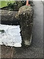
Boundary stone on Agar Road
Inscription reads:-
1815
Truro
15
Pool
2½
Cut benchmark
Image: © Ben Chmark
Taken: 26 Oct 2023
0.12 miles