IMAGES TAKEN NEAR TO
Mount Carbis Road, REDRUTH, TR15 2LD
Introduction
This page details the photographs taken nearby to Mount Carbis Road, TR15 2LD by members of the Geograph project.
The Geograph project started in 2005 with the aim of publishing, organising and preserving representative images for every square kilometre of Great Britain, Ireland and the Isle of Man.

There are currently over 7.5m images from over14,400 individuals and you can help contribute to the project by visiting https://www.geograph.org.uk
Image Map
Images are licensed for reuse under creativecommons.org/licenses/by-sa/2.0
Notes
- Clicking on the map will re-center to the selected point.
- The higher the marker number, the further away the image location is from the centre of the postcode.
Image Listing (19 Images Found)
Images are licensed for reuse under creativecommons.org/licenses/by-sa/2.0
Image
Details
Distance
1
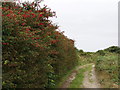
Fuchsia hedge outside Redruth
An old lane leads down from Myrtle Farm to the A393 road from Redruth to Falmouth.
Image: © Sheila Russell
Taken: 6 Aug 2005
0.07 miles
2

Redruth War Memorial
Sited in Victoria Park, Redruth
Image: © Andrew Harvey
Taken: 30 Apr 2005
0.07 miles
5
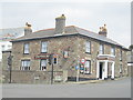
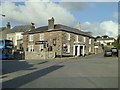
The Trefusis Arms Inn, Redruth
On Falmouth Road.
Image: © JThomas
Taken: 11 Jul 2017
0.14 miles
6
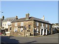
Trefusis Arms
Trefusis Arms on Falmouth Road in Redruth.
Image: © Philip Halling
Taken: 7 Nov 2017
0.14 miles
7
The Trefusis Arms inn, Falmouth Road, Redruth
Image: © David Smith
Taken: 14 Mar 2016
0.14 miles
8
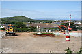
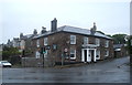
New Development on the Outskirts of Redruth
I don't know what is being built here, there was no indication. As it is adjacent to a residential area it could be houses but then again with the main A393 road running just behind the photographer it would make a good location for a commercial or industrial development.
Image: © Tony Atkin
Taken: 7 Jun 2008
0.14 miles
9
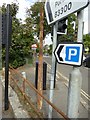
Old Direction Sign - Signpost by the B3297, Falmouth Road, Redruth
No finial, no arms - by the B3297, in parish of Redruth (Kerrier District), junction of Clinton Road with Falmouth Road, on pavement on apex of junction.
To be surveyed
Milestone Society National ID: CW_SW7041
Image: © Milestone Society
Taken: Unknown
0.14 miles
10
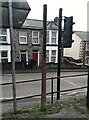
Direction Sign – Signpost on Falmouth Road, Redruth
Located on the pavement on the northwest side of the junction of the B3300 Falmouth Road and Clinton Road. Redruth parish. Arms and finial missing. See also https://www.geograph.org.uk/photo/6096008 and https://www.geograph.org.uk/photo/7967508.
Milestone Society National ID: CW_SW7041
Image: © P Barnett
Taken: 2 Feb 2025
0.14 miles