1
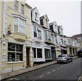
The Glass Slipper in Redruth
The shop on the right at 47 Fore Street sells a variety of dresses,
such as prom, evening, bridesmaid, flower girl, holy communion and christening.
Image: © Jaggery
Taken: 4 Jun 2016
0.02 miles
2
Redruth Station
Upline from the footbridge.
Image: © Tom Jolliffe
Taken: 15 Oct 2008
0.02 miles
3
Ornamental tree surround, Station Road, Redruth
This is quite a brave place to plant a tree - in the middle of the pavement. The cast iron surround is attractive and is redolent of Parisian streets, perhaps.
Image: © Tom Jolliffe
Taken: 3 Jun 2010
0.02 miles
4
Amity in Redruth
Indian cuisine restaurant and takeaway at 5 Higher Fore Street.
Image: © Jaggery
Taken: 4 Jun 2016
0.02 miles
5
The Top of Fore Street
Fore Street is the main shopping street in Redruth. It descends quite steeply from here to the bottom of the valley.
Image: © Tony Atkin
Taken: 7 Jun 2008
0.02 miles
6
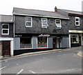
Crystal Image Jewellers in Redruth
On the left at 43 Fore Street. Jan-Kel hairdressers is next door.
Image: © Jaggery
Taken: 4 Jun 2016
0.02 miles
7
Benchmark bolt
Image: © Paul Barnett
Taken: 28 Mar 2023
0.03 miles
8
Top of Station Road, Redruth
Approaching its junction with Fore Street (left), Higher Fore Street (ahead), and Wesley Street (right). The greenery on the right is on the side of the cutting at the north east end of Redruth railway station, at the south end of a short tunnel.
Image: © Richard Vince
Taken: 3 Oct 2023
0.03 miles
9
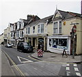
Dominant tree on a Redruth corner
Viewed from the eastern end of Fore Street. The car is at the western end of Wesley Street.
Grade II listed Wesley Buildings http://www.geograph.org.uk/photo/4988076 are on the right.
Image: © Jaggery
Taken: 4 Jun 2016
0.03 miles
10
Wesley Street railway bridge, Redruth
Viewed from Redruth railway station. The bridge carries Wesley Street over the Cornish main line.
Next station ahead is Truro.
Image: © Jaggery
Taken: 4 Jun 2016
0.03 miles


