IMAGES TAKEN NEAR TO
West End, REDRUTH, TR15 1TE
Introduction
This page details the photographs taken nearby to West End, TR15 1TE by members of the Geograph project.
The Geograph project started in 2005 with the aim of publishing, organising and preserving representative images for every square kilometre of Great Britain, Ireland and the Isle of Man.

There are currently over 7.5m images from over14,400 individuals and you can help contribute to the project by visiting https://www.geograph.org.uk
Image Map
Images are licensed for reuse under creativecommons.org/licenses/by-sa/2.0
Notes
- Clicking on the map will re-center to the selected point.
- The higher the marker number, the further away the image location is from the centre of the postcode.
Image Listing (73 Images Found)
Images are licensed for reuse under creativecommons.org/licenses/by-sa/2.0
Image
Details
Distance
1
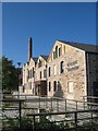
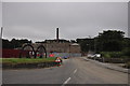
Kresen Kernow archives centre
The Cornwall archives centre, risen anew from the derelict Redruth Brewery. There is no subject category for archives now, so I have no idea what other designation to use.
Image: © Jonathan Wilkins
Taken: 19 Sep 2019
0.09 miles
2
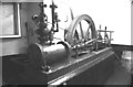
Former Devenish Redruth brewery, steam engine.
This engine was still workable and was seen running. It was installed in 1870 and was possibly by the Redruth Foundry Co. It was removed for preservation in 1987 and its current location is not known. There was a smaller engine upstairs and this was removed much more recently to Germany.
Image: © Chris Allen
Taken: 19 May 1982
0.09 miles
3
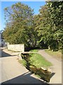
Portreath Stream
A section of highly urbanised waterway on this rather abused stream which seems to run underground through most of Redruth.
Image: © Jonathan Wilkins
Taken: 19 Sep 2019
0.10 miles
5
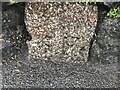
Old Boundary Marker on West Road, Redruth
Mine Boundary Marker set in a stone wall on the north side of West Road 10 metres west of the entrance to the Penventon Hotel. Inscribed 5 F. The stone records the Fairmeadow mining sett boundary.
Milestone Society National ID: CW_REDRU12em
Image: © P Barnett
Taken: 9 Mar 2023
0.13 miles
6
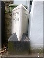
Old Milestone by the former A3047, West End, Redruth
Carved stone post by the former A3047, in parish of REDRUTH (KERRIER District), Redruth centre, by No. 32 West End's Garden, part of front wall, on South side of road. Erected by the Local Highways Board in the 19th century.
Inscription reads:-
: CAMBORNE / 3 / PENZANCE / 17 : : TRURO / 9 :
Grade II listed.
List Entry Number: 1409467
Milestone Society National ID: CW_PZRR17.
Image: © Paul Barnett
Taken: 5 Dec 2022
0.14 miles
7
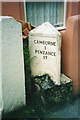
Old Milestone by the former A3047, West End, Redruth
Carved stone post by the former A3047, in parish of REDRUTH (KERRIER District), Redruth centre, by No. 32 West End's Garden, part of front wall, on South side of road. Erected by the Local Highways Board in the 19th century.
Inscription reads:-
: CAMBORNE / 3 / PENZANCE / 17 : : TRURO / 9 :
Grade II listed.
List Entry Number: 1409467 https://historicengland.org.uk/listing/the-list/list-entry/1409467
Milestone Society National ID: CW_PZRR17.
Image: © Rosy Hanns
Taken: 2 May 2019
0.14 miles
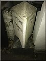
8
Old Milestone by West End, Redruth
Carved stone post by the former A3047, in parish of REDRUTH (KERRIER District), Redruth centre, by No. 32 West End's Garden, part of front wall, on South side of road. Erected by the Local Highways Board in the 19th century.
Inscription reads:-
: CAMBORNE / 3 / PENZANCE / 17 : : TRURO / 9 :
Grade II listed.
List Entry Number: 1409467 https://historicengland.org.uk/listing/the-list/list-entry/1409467
Milestone Society National ID: CW_PZRR17.
Image: © Ian Thompson
Taken: Unknown
0.14 miles
9
Redruth : Small Road
A small road leading to the old brewery.
Image: © Lewis Clarke
Taken: 13 Jul 2015
0.14 miles
10
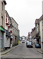
West along West End, Redruth
Viewed across the B3300 from the western end of Fore Street.
Image: © Jaggery
Taken: 4 Jun 2016
0.14 miles