IMAGES TAKEN NEAR TO
Mount Ambrose, REDRUTH, TR15 1QS
Introduction
This page details the photographs taken nearby to TR15 1QS by members of the Geograph project.
The Geograph project started in 2005 with the aim of publishing, organising and preserving representative images for every square kilometre of Great Britain, Ireland and the Isle of Man.

There are currently over 7.5m images from over14,400 individuals and you can help contribute to the project by visiting https://www.geograph.org.uk
Image Map
Images are licensed for reuse under creativecommons.org/licenses/by-sa/2.0
Notes
- Clicking on the map will re-center to the selected point.
- The higher the marker number, the further away the image location is from the centre of the postcode.
Image Listing (20 Images Found)
Images are licensed for reuse under creativecommons.org/licenses/by-sa/2.0
Image
Details
Distance
4
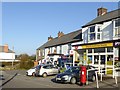
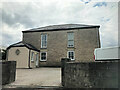
Mount Ambrose inn, stores and post office
Image: © David Smith
Taken: 14 Mar 2016
0.04 miles
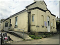
5
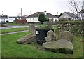
Roadside Display, Redruth
A display involving granite blocks, a mine cart and plants near a roundabout in a suburban area of north Redruth
Image: © Tony Atkin
Taken: 31 Dec 2005
0.04 miles
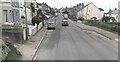
6
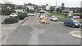
Roundabout at junction of A393 and A3047
Image: © Paul Barnett
Taken: 8 Feb 2023
0.07 miles
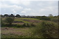
7
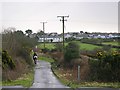
Outskirts of Redruth
A horse rider makes their way down the path towards the railway line hidden between the fields.
Image: © Tony Atkin
Taken: 31 Dec 2005
0.12 miles