
IMAGES TAKEN NEAR TO
Miners Court, Miners Row, REDRUTH, TR15 1NJ
Introduction
This page details the photographs taken nearby to Miners Court, Miners Row, TR15 1NJ by members of the Geograph project.
The Geograph project started in 2005 with the aim of publishing, organising and preserving representative images for every square kilometre of Great Britain, Ireland and the Isle of Man.

There are currently over 7.5m images from over14,400 individuals and you can help contribute to the project by visiting https://www.geograph.org.uk
Image Map
Images are licensed for reuse under creativecommons.org/licenses/by-sa/2.0
Notes
- Clicking on the map will re-center to the selected point.
- The higher the marker number, the further away the image location is from the centre of the postcode.
Image Listing (171 Images Found)
Images are licensed for reuse under creativecommons.org/licenses/by-sa/2.0
Image
Details
Distance
1
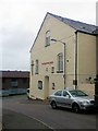
Redruth Salvation Army
Near to train station
Image: © Paul Barnett
Taken: 28 Oct 2015
0.05 miles
2
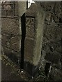
Old Milestone by the former A3047, East End, Redruth
Carved stone post by the A3047, in parish of REDRUTH (KERRIER District), East End, by No 32, against the wall, on North side of road. Erected by the parish in the 18th century.
Inscription reads:-
: 18 / P : : 28 / L :
Carved benchmark on lower front face.
Grade II Listed. List Entry Number: 1142590
Milestone Society National ID: CW_PZL18.
Image: © Paul Barnett
Taken: 3 Jan 2023
0.05 miles
3
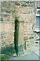
Old Milestone by the former A3047, East End, Redruth
Carved stone post by the A3047, in parish of REDRUTH (KERRIER District), East End, by No 32, against the wall, on North side of road. Erected by the parish in the 18th century.
Inscription reads:-
: 18 / P : : 28 / L :
Carved benchmark on lower front face.
Grade II Listed. List Entry Number: 1142590
https://historicengland.org.uk/listing/the-list/list-entry/1142590
Milestone Society National ID: CW_PZL18.
Image: © Ian Thompson
Taken: 10 Dec 2017
0.05 miles
4
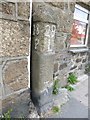
Old Milestone by the former A3047, East End, Redruth
Carved stone post by the former A3047, in parish of REDRUTH (KERRIER District), East End, by No 32, against the wall, on North side of road. Erected by the parish in the 18th century.
Inscription reads:-
: 18 / P : : 28 / L :
Carved benchmark on lower front face.
Grade II listed.
List Entry Number: 1142590 https://historicengland.org.uk/listing/the-list/list-entry/1142590
Milestone Society National ID: CW_PZL18.
Image: © Rosy Hanns
Taken: 1 Jun 2019
0.06 miles
5
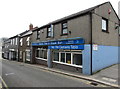
Macks Fish & Steak Bar and the Captain's Table, Redruth
Takeaway and restaurant at 9 Higher Fore Street.
Image: © Jaggery
Taken: 4 Jun 2016
0.09 miles
6
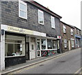
Manolya and Candy Cane in Redruth
Manolya is a nail & beauty salon at 6 Higher Fore Street. Candy Cane tattoo parlour is next door.
Image: © Jaggery
Taken: 4 Jun 2016
0.09 miles
7
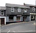
Amity in Redruth
Indian cuisine restaurant and takeaway at 5 Higher Fore Street.
Image: © Jaggery
Taken: 4 Jun 2016
0.09 miles
8
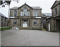
Wesley Buildings, Redruth
Set back from Station Road on the south side of Wesley Street, the late Victorian Wesley Buildings are managed by the Methodist Church in Redruth for the benefit of the community.
The inscription above the doorway is WESLEY CENTENARY MEMORIAL 1891. The centenary in question is the hundred years since the death of John Wesley, one of the founders of Methodism. He died in March 1791.
The building was Grade II listed (as Wesley Centenary Memorial Hall) in 1989.
Redruth Methodist Church http://www.geograph.org.uk/photo/4988086 is on the right.
Image: © Jaggery
Taken: 4 Jun 2016
0.11 miles
9
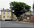
Dominant tree on a Redruth corner
Viewed from the eastern end of Fore Street. The car is at the western end of Wesley Street.
Grade II listed Wesley Buildings http://www.geograph.org.uk/photo/4988076 are on the right.
Image: © Jaggery
Taken: 4 Jun 2016
0.11 miles
10
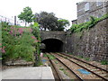
Wesley Street railway bridge, Redruth
Viewed from Redruth railway station. The bridge carries Wesley Street over the Cornish main line.
Next station ahead is Truro.
Image: © Jaggery
Taken: 4 Jun 2016
0.11 miles