IMAGES TAKEN NEAR TO
North Street, REDRUTH, TR15 1DZ
Introduction
This page details the photographs taken nearby to North Street, TR15 1DZ by members of the Geograph project.
The Geograph project started in 2005 with the aim of publishing, organising and preserving representative images for every square kilometre of Great Britain, Ireland and the Isle of Man.

There are currently over 7.5m images from over14,400 individuals and you can help contribute to the project by visiting https://www.geograph.org.uk
Image Map
Images are licensed for reuse under creativecommons.org/licenses/by-sa/2.0
Notes
- Clicking on the map will re-center to the selected point.
- The higher the marker number, the further away the image location is from the centre of the postcode.
Image Listing (9 Images Found)
Images are licensed for reuse under creativecommons.org/licenses/by-sa/2.0
Image
Details
Distance
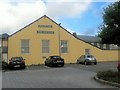
1
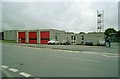
Redruth Fire Station
Redruth Fire Station, Close Hill, Redruth, Cornwall.
Image: © Kevin Hale
Taken: 26 Jul 1992
0.17 miles
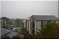
4
Scout building
Former Primitive Methodist church
Image: © Paul Barnett
Taken: 28 Oct 2015
0.22 miles
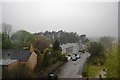
6
Green Lane Church
Opposite is a large Christian statue
Image: © Paul Barnett
Taken: 28 Oct 2015
0.23 miles
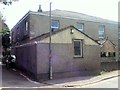
7
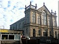
Former Primitive Methodist church
Former church opposite
Image: © Paul Barnett
Taken: 28 Oct 2015
0.23 miles
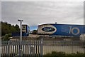
8
Redruth : Small Road
A small road leading to the old brewery.
Image: © Lewis Clarke
Taken: 13 Jul 2015
0.25 miles
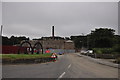
9
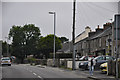
Redruth : Chapel Street B3300
A road heading through the centre of Redruth.
Image: © Lewis Clarke
Taken: 13 Jul 2015
0.25 miles