IMAGES TAKEN NEAR TO
Black Rock, CAMBORNE, TR14 9PN
Introduction
This page details the photographs taken nearby to TR14 9PN by members of the Geograph project.
The Geograph project started in 2005 with the aim of publishing, organising and preserving representative images for every square kilometre of Great Britain, Ireland and the Isle of Man.

There are currently over 7.5m images from over14,400 individuals and you can help contribute to the project by visiting https://www.geograph.org.uk
Image Map
Images are licensed for reuse under creativecommons.org/licenses/by-sa/2.0
Notes
- Clicking on the map will re-center to the selected point.
- The higher the marker number, the further away the image location is from the centre of the postcode.
Image Listing (15 Images Found)
Images are licensed for reuse under creativecommons.org/licenses/by-sa/2.0
Image
Details
Distance

4
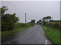
Looking north east on the B3280, Black Rock
Image: © JThomas
Taken: 11 Jul 2017
0.17 miles
5
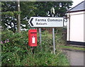
Elizabeth II postbox, Blackrock
Postbox No. TR14 112.
Image: © JThomas
Taken: 11 Jul 2017
0.17 miles
6
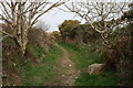
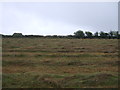
Bridle path near Cargenwen
The bridle path passes between fields and gorse bushes and small trees grow alongside it.
Image: © Elizabeth Scott
Taken: 26 Mar 2011
0.17 miles
7
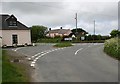
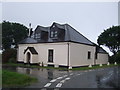
Road Junction near Blackrock Farm
There is a small scattering of houses and a couple of farms here.
Image: © Tony Atkin
Taken: 20 May 2006
0.19 miles
8
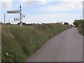
Finger post and country road
Not only is this a pre-worboys sign post (very common in this rural area) but an example of a finger post deliberately designed to point in the opposite direction to the usual orientation of a finger post!
Image: © Hywel Williams
Taken: 4 Jun 2017
0.21 miles
9
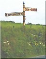
Old Direction Sign - Signpost by the B3280, north of Black Rock, Crowan Parish
Cone finial - Visick Cone by the B3280, in parish of Crowan (Kerrier District), Black Rock, just West of Crowan Beacon, on Cornish hedge.
Surveyed
Milestone Society National ID: CW_SW6635
Image: © Milestone Society
Taken: Unknown
0.22 miles
10
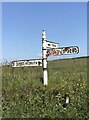
Direction Sign - Signpost by the B3280 north of Black Rock
Located on the east side of a junction on the B3280 340 metres north of Blackrock. Crowan parish. 3 arms and cone finial. The TROON 2 arm was broken off at the sleeve in the earlier photo https://www.geograph.org.uk/photo/6043324, but was replaced by September 2021. See also http://www.geograph.org.uk/photo/5415975.
Milestone Society National ID: CW_SW6635
Image: © P Barnett
Taken: 25 Jun 2024
0.22 miles