IMAGES TAKEN NEAR TO
Higher Stennack, CAMBORNE, TR14 9JS
Introduction
This page details the photographs taken nearby to Higher Stennack, TR14 9JS by members of the Geograph project.
The Geograph project started in 2005 with the aim of publishing, organising and preserving representative images for every square kilometre of Great Britain, Ireland and the Isle of Man.

There are currently over 7.5m images from over14,400 individuals and you can help contribute to the project by visiting https://www.geograph.org.uk
Image Map (Loading...)


Getting Data...Please wait
Leaflet Map data © OpenStreetMap
Images are licensed for reuse under creativecommons.org/licenses/by-sa/2.0
Notes
- Clicking on the map will re-center to the selected point.
- The higher the marker number, the further away the image location is from the centre of the postcode.
Image Listing (5 Images Found)
Images are licensed for reuse under creativecommons.org/licenses/by-sa/2.0
Image
Details
Distance
2
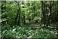
Stennack
Stennack is a hamlet in a wooded valley on the western edge of Troon.
Image: © Tony Atkin
Taken: 29 May 2006
0.17 miles
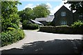
3
Location of Troon FBM Aux 1
http://trigpointing.uk/trig/638
Image: © thejackrustles
Taken: 21 Jun 2021
0.19 miles
4
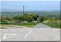
Minor Road Junction near Copper Hill
Looking to the northeast out over the square. Most of the rest of the land in the square disappears into the valley. The land in the distance is the lowlands around Hayle and across St Ives bay to St Ives itself in the haze.
Image: © Tony Atkin
Taken: 29 May 2006
0.19 miles
