IMAGES TAKEN NEAR TO
School Lane, CAMBORNE, TR14 9EY
Introduction
This page details the photographs taken nearby to School Lane, TR14 9EY by members of the Geograph project.
The Geograph project started in 2005 with the aim of publishing, organising and preserving representative images for every square kilometre of Great Britain, Ireland and the Isle of Man.

There are currently over 7.5m images from over14,400 individuals and you can help contribute to the project by visiting https://www.geograph.org.uk
Image Map (Loading...)


Getting Data...Please wait
Leaflet Map data © OpenStreetMap
Images are licensed for reuse under creativecommons.org/licenses/by-sa/2.0
Notes
- Clicking on the map will re-center to the selected point.
- The higher the marker number, the further away the image location is from the centre of the postcode.
Image Listing (10 Images Found)
Images are licensed for reuse under creativecommons.org/licenses/by-sa/2.0
Image
Details
Distance
1
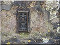
Ordnance Survey Flush Bracket S6926
This bracket can be found on the wall of Troon Community Primary School. The benchmark height is recorded as being 168.609 metres above sea level.
For more detail see : http://www.bench-marks.org.uk/bm15399
Image: © Peter Wood
Taken: 30 Apr 2017
0.02 miles
2
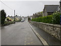
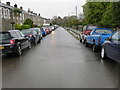
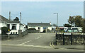
New Road in Troon
Looking north-westward from beside the school.
Image: © Peter Wood
Taken: 30 Apr 2017
0.03 miles
3
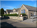
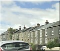
Troon Community Primary School
The building also houses the Family Activity Centre.
Image: © Rod Allday
Taken: 22 Oct 2010
0.04 miles
4
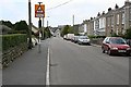
New Road, Troon
Troon is a large village just south of Camborne. With the development of several mines around the village in the 19th century, Troon grew rapidly from a tiny hamlet into a village almost large enough to call a town.
Image: © Tony Atkin
Taken: 20 May 2006
0.06 miles
6
Pendarves Street in Troon
Looking south-westward.
Image: © Peter Wood
Taken: 30 Apr 2017
0.11 miles
7
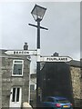
Direction Sign – Signpost on Fore Street, Troon
Two arms fixed to a street lamp outside no.27 Fore Street, Troon, on the northeast side of the junction of Fore Street and New Road. Camborne parish.
Milestone Society National ID: CW_SW6638
Image: © P Barnett
Taken: 8 Apr 2024
0.11 miles
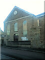
9
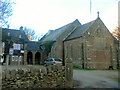
Mission Church with adjoining Sunday School at left
Image: © Paul Barnett
Taken: 16 Jan 2015
0.21 miles