IMAGES TAKEN NEAR TO
Codiford Crescent, CAMBORNE, TR14 8UF
Introduction
This page details the photographs taken nearby to Codiford Crescent, TR14 8UF by members of the Geograph project.
The Geograph project started in 2005 with the aim of publishing, organising and preserving representative images for every square kilometre of Great Britain, Ireland and the Isle of Man.

There are currently over 7.5m images from over14,400 individuals and you can help contribute to the project by visiting https://www.geograph.org.uk
Image Map (Loading...)


Getting Data...Please wait
Leaflet Map data © OpenStreetMap
Images are licensed for reuse under creativecommons.org/licenses/by-sa/2.0
Notes
- Clicking on the map will re-center to the selected point.
- The higher the marker number, the further away the image location is from the centre of the postcode.
Image Listing (11 Images Found)
Images are licensed for reuse under creativecommons.org/licenses/by-sa/2.0
Image
Details
Distance
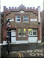
1
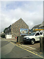
Former Drill Hall - North Roskear Road
One of two large buildings on the site in use in 1914.
Image: © John M
Taken: 9 Sep 2014
0.12 miles
2
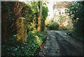
Old Milestone near the former Rosewarne Home Farm
Carved stone post by the UC road, in parish of CAMBORNE (KERRIER District), Holman Park, Tehidy Road, West side of drive to Rosewarne Home Farm, in new (2008) housing development in grounds of Gladys Holman House, on West side of road. Erected by the parish in the 18th century.
Inscription reads:-
: 14 / P : : 24 / L :
Grade II Listed. List Entry Number: 1310753
https://historicengland.org.uk/listing/the-list/list-entry/1310753
Milestone Society National ID: CW_LAP24.
Image: © Ian Thompson
Taken: 1 Feb 2007
0.16 miles
3
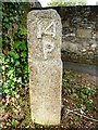
Old Milestone near the former Rosewarne Home Farm - SE face
Carved stone post by the UC road, in parish of CAMBORNE (KERRIER District), Holman Park, Tehidy Road, West side of drive to Rosewarne Home Farm, in new (2008) housing development in grounds of Gladys Holman House, on West side of road. Erected by the parish in the 18th century.
Inscription reads:-
: 14 / P : : 24 / L :
Grade II listed.
List Entry Number: 1310753 https://historicengland.org.uk/listing/the-list/list-entry/1310753
Milestone Society National ID: CW_LAP24.
Image: © Rosy Hanns
Taken: 5 Jul 2019
0.16 miles
4
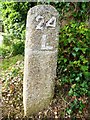
Old Milestone near the former Rosewarne Home Farm - NW face
Carved stone post by the UC road, in parish of CAMBORNE (KERRIER District), Holman Park, Tehidy Road, West side of drive to Rosewarne Home Farm, in new (2008) housing development in grounds of Gladys Holman House, on West side of road. Erected by the parish in the 18th century.
Inscription reads:-
: 14 / P : : 24 / L :
Grade II listed.
List Entry Number: 1310753 https://historicengland.org.uk/listing/the-list/list-entry/1310753
Milestone Society National ID: CW_LAP24.
Image: © Rosy Hanns
Taken: 5 Jul 2019
0.16 miles
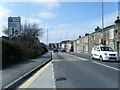
7
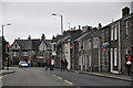
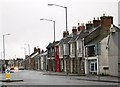
Camborne : Wesley Street
Looking along Wesley Street in Camborne.
Image: © Lewis Clarke
Taken: 13 Jul 2015
0.21 miles