IMAGES TAKEN NEAR TO
Dolcoath Industrial Park, Dolcoath Road, CAMBORNE, TR14 8RA
Introduction
This page details the photographs taken nearby to Dolcoath Industrial Park, Dolcoath Road, TR14 8RA by members of the Geograph project.
The Geograph project started in 2005 with the aim of publishing, organising and preserving representative images for every square kilometre of Great Britain, Ireland and the Isle of Man.

There are currently over 7.5m images from over14,400 individuals and you can help contribute to the project by visiting https://www.geograph.org.uk
Image Map (Loading...)


Getting Data...Please wait
Leaflet Map data © OpenStreetMap
Images are licensed for reuse under creativecommons.org/licenses/by-sa/2.0
Notes
- Clicking on the map will re-center to the selected point.
- The higher the marker number, the further away the image location is from the centre of the postcode.
Image Listing (33 Images Found)
Images are licensed for reuse under creativecommons.org/licenses/by-sa/2.0
Image
Details
Distance
1
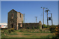
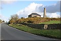
Dolcoath Mine, New East Shaft
This is the whim (winding) engine house and boiler house. This would have housed a beam (steam) winding engine with the drums outdoors. In about 1913 it was converted to a transformer house the bob opening was filled in with a new arched window. Ceramic pipes penetrate the end walls and would have carried conductors (probably bare).
Image: © Chris Allen
Taken: 28 Apr 2011
0.03 miles
2
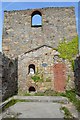
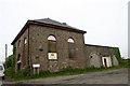
Dolcoath Mine - Whim House
The former eastern whim house for this mine, later converted to an electricity substation and now conserved. The boiler house is a rare survival.
Note the window alterations around the roof area.
Image: © Ashley Dace
Taken: 5 Sep 2012
0.03 miles
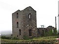
3

Dolcoath Mine - Whim House
The former eastern whim house for this mine, later converted to an electricity substation and now conserved. The boiler house is a rare survival.
Image: © Ashley Dace
Taken: 5 Sep 2012
0.03 miles
4
Engine House at Dolcoath Mine
After the mine was closed this building was used for a while as an electricity sub-station.
Image: © Tony Atkin
Taken: 30 Dec 2005
0.04 miles
5
Minor road, Tuckingmill
Looking north west.
Image: © JThomas
Taken: 10 Jul 2017
0.08 miles
6

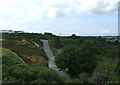
Spoils of industry at Tucking Mill
This area between Camborne and Redruth contains much evidence of the former tin and copper mining industries. Even the name of the river in this shallow valley, Red River, reminds us of the colour of the soil from the copper. The valley is greener now, as nature returns.
The railway crosses on a shallow viaduct here and this photo was taken from the 1158 Penzance to London Paddington train, having left Camborne at 1224.
Image: © Graham Horn
Taken: 9 Jul 2011
0.08 miles
8
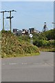
Road Junction
South Crofty mine dominates the landscape around here. The bins etc. have permission to be demolished, but it's probable the shaft will survive owing to its Landmark status.
Image: © Ashley Dace
Taken: 5 Sep 2012
0.09 miles
9
Dolcoath Road
Old mine buildings on Dolcoath Road
Image: © Helen Wilkinson
Taken: 12 Jun 2009
0.10 miles
10
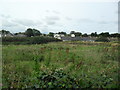
Tuckingmill
Disused land soon to be used for a bypass, subject to approval.
Image: © Burgess Von Thunen
Taken: 20 Sep 2012
0.12 miles