IMAGES TAKEN NEAR TO
East Hill, CAMBORNE, TR14 8QL
Introduction
This page details the photographs taken nearby to East Hill, TR14 8QL by members of the Geograph project.
The Geograph project started in 2005 with the aim of publishing, organising and preserving representative images for every square kilometre of Great Britain, Ireland and the Isle of Man.

There are currently over 7.5m images from over14,400 individuals and you can help contribute to the project by visiting https://www.geograph.org.uk
Image Map
Images are licensed for reuse under creativecommons.org/licenses/by-sa/2.0
Notes
- Clicking on the map will re-center to the selected point.
- The higher the marker number, the further away the image location is from the centre of the postcode.
Image Listing (32 Images Found)
Images are licensed for reuse under creativecommons.org/licenses/by-sa/2.0
Image
Details
Distance
1

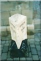
Old Boundary Marker on East Hill, Tuckingmill
Mine Boundary Marker, broken and set on its side near the base of a high stone front garden wall on the northwest side of East Hill, Tuckingmill. Carn Brea parish. Inscribed B / 5½. Thought to mark the boundary of North Crofty mine.
Milestone Society National ID: CW_CARNB05em
Image: © I Thompson
Taken: 5 Feb 2023
0.02 miles
2
Camborne : Tolvaddon Road
Looking along the road with Camborne Retail Park in view.
Image: © Lewis Clarke
Taken: 13 Jul 2015
0.08 miles
4
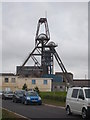
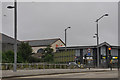
Headgear at South Crofty Mine
South Crofty was the last operational tin mine in Cornwall when it closed in 1998. There are currently (July 2012) hopes that it will soon recommence working.
Image: © Rod Allday
Taken: 24 Jun 2012
0.10 miles
5
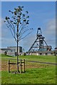
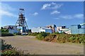
Regeneration of the Mine Site
The target next is South Crofty I think after £35 million has been spent on Robinson's Shaft.
Image: © Ashley Dace
Taken: 4 Sep 2012
0.11 miles
8
Old Milestone in Carn Brea parish
Carved stone post by the A3047, in parish of CARN BREA (KERRIER District), Trevenson Road, Pool, by B&Q store, Tuckingmill, against wall of B&Q superstore, on South side of road. Erected by the Local Highways Board in the 19th century.
Inscription reads:-
: CAMBORNE / 1 / PENZANCE / 15 : : REDRUTH / 2 / TRURO / 11 :
Grade II Listed. List Entry Number: 1142599
https://historicengland.org.uk/listing/the-list/list-entry/1142599
Milestone Society National ID: CW_PZRR15.
Image: © Ian Thompson
Taken: 1 May 2004
0.12 miles
9
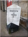
Old Milestone in Carn Brea parish
Carved stone post by the UC road (former A3047), in parish of CARN BREA (KERRIER District), Trevenson Road, Pool, Tuckingmill, against wall of B&Q superstore, on South side of road. Erected by the Local Highways Board in the 19th century.
Inscription reads:-
: CAMBORNE / 1 / PENZANCE / 15 : : REDRUTH / 2 / TRURO / 11 :
Carved bench mark on lower righthand face.
Grade II listed.
List Entry Number: 1142599 https://historicengland.org.uk/listing/the-list/list-entry/1142599
Milestone Society National ID: CW_PZRR15.
Image: © Rosy Hanns
Taken: 1 Jun 2019
0.13 miles
10
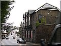
The Main Road Through Tuckingmill
The building in the foreground used to be part of the factory making safety fuses, invented by William Bickford.
Image: © Tony Atkin
Taken: 30 Dec 2005
0.13 miles