
IMAGES TAKEN NEAR TO
North Roskear Road, CAMBORNE, TR14 8NF
Introduction
This page details the photographs taken nearby to North Roskear Road, TR14 8NF by members of the Geograph project.
The Geograph project started in 2005 with the aim of publishing, organising and preserving representative images for every square kilometre of Great Britain, Ireland and the Isle of Man.

There are currently over 7.5m images from over14,400 individuals and you can help contribute to the project by visiting https://www.geograph.org.uk
Image Map
Images are licensed for reuse under creativecommons.org/licenses/by-sa/2.0
Notes
- Clicking on the map will re-center to the selected point.
- The higher the marker number, the further away the image location is from the centre of the postcode.
Image Listing (4 Images Found)
Images are licensed for reuse under creativecommons.org/licenses/by-sa/2.0
Image
Details
Distance
1
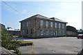
Former Drill Hall - North Roskear Road
One of two large buildings on the site in use in 1914.
Image: © John M
Taken: 9 Sep 2014
0.03 miles
3
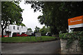
Camborne : Blackwood House
Looking towards Blackwood House in Camborne.
Image: © Lewis Clarke
Taken: 13 Jul 2015
0.22 miles
4
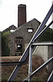
New Roskear Mine, Camborne
This was latterly an alternative access for South Crofty and closed with that mine. The derelict winding engine house contained the incomplete remains (just visible through the doorway) of a duplex steam winding engine. Built 1897 and moved here in 1924. In 2005 the remains were removed to South Crofty as part of a World heritage bid project. I have no idea what this site now looks like.
Image: © Chris Allen
Taken: 6 Apr 2000
0.23 miles