IMAGES TAKEN NEAR TO
North Road, CAMBORNE, TR14 8AR
Introduction
This page details the photographs taken nearby to North Road, TR14 8AR by members of the Geograph project.
The Geograph project started in 2005 with the aim of publishing, organising and preserving representative images for every square kilometre of Great Britain, Ireland and the Isle of Man.

There are currently over 7.5m images from over14,400 individuals and you can help contribute to the project by visiting https://www.geograph.org.uk
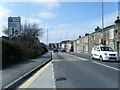
Image Map
Images are licensed for reuse under creativecommons.org/licenses/by-sa/2.0
Notes
- Clicking on the map will re-center to the selected point.
- The higher the marker number, the further away the image location is from the centre of the postcode.
Image Listing (48 Images Found)
Images are licensed for reuse under creativecommons.org/licenses/by-sa/2.0
Image
Details
Distance
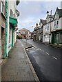
2
Mid Trelowarren Street
The middle section of Trelowarren Street looking west.
Image: © Jay Pea
Taken: 24 Dec 2021
0.05 miles
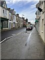
3
Trelowarren Street
The eastern end of Trelowarren Street.
Image: © Jay Pea
Taken: 24 Dec 2021
0.08 miles
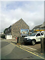
4
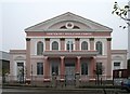
Centenary Wesleyan Church
This is one of many large non-conformist churches in the Camborne area, but one of the few still used. Its size demonstrates the strength of the non-conformist movement in 19th century Cornwall and the money which was available to build such structures in the early 19th century boom.
Image: © Tony Atkin
Taken: 30 Dec 2005
0.10 miles
5
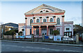
Centenary Wesleyan Church
Church on Wesley Street. http://camborne-redruth.org/chapels/centenary-methodist-church/
Image: © David P Howard
Taken: 12 Jan 2016
0.10 miles
6
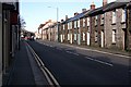
Centenary Street, Camborne
This is a busy main road lined with small terraced houses just on the edge of Camborne town centre.
Image: © Tony Atkin
Taken: 3 Mar 2007
0.11 miles
7
Old Milestone near the former Rosewarne Home Farm
Carved stone post by the UC road, in parish of CAMBORNE (KERRIER District), Holman Park, Tehidy Road, West side of drive to Rosewarne Home Farm, in new (2008) housing development in grounds of Gladys Holman House, on West side of road. Erected by the parish in the 18th century.
Inscription reads:-
: 14 / P : : 24 / L :
Grade II Listed. List Entry Number: 1310753
https://historicengland.org.uk/listing/the-list/list-entry/1310753
Milestone Society National ID: CW_LAP24.
Image: © Ian Thompson
Taken: 1 Feb 2007
0.11 miles
8
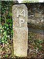
Old Milestone near the former Rosewarne Home Farm - SE face
Carved stone post by the UC road, in parish of CAMBORNE (KERRIER District), Holman Park, Tehidy Road, West side of drive to Rosewarne Home Farm, in new (2008) housing development in grounds of Gladys Holman House, on West side of road. Erected by the parish in the 18th century.
Inscription reads:-
: 14 / P : : 24 / L :
Grade II listed.
List Entry Number: 1310753 https://historicengland.org.uk/listing/the-list/list-entry/1310753
Milestone Society National ID: CW_LAP24.
Image: © Rosy Hanns
Taken: 5 Jul 2019
0.11 miles
9
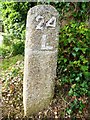
Old Milestone near the former Rosewarne Home Farm - NW face
Carved stone post by the UC road, in parish of CAMBORNE (KERRIER District), Holman Park, Tehidy Road, West side of drive to Rosewarne Home Farm, in new (2008) housing development in grounds of Gladys Holman House, on West side of road. Erected by the parish in the 18th century.
Inscription reads:-
: 14 / P : : 24 / L :
Grade II listed.
List Entry Number: 1310753 https://historicengland.org.uk/listing/the-list/list-entry/1310753
Milestone Society National ID: CW_LAP24.
Image: © Rosy Hanns
Taken: 5 Jul 2019
0.11 miles