IMAGES TAKEN NEAR TO
Lady Drive, CAMBORNE, TR14 7UF
Introduction
This page details the photographs taken nearby to Lady Drive, TR14 7UF by members of the Geograph project.
The Geograph project started in 2005 with the aim of publishing, organising and preserving representative images for every square kilometre of Great Britain, Ireland and the Isle of Man.

There are currently over 7.5m images from over14,400 individuals and you can help contribute to the project by visiting https://www.geograph.org.uk
Image Map (Loading...)


Getting Data...Please wait
Leaflet Map data © OpenStreetMap
Images are licensed for reuse under creativecommons.org/licenses/by-sa/2.0
Notes
- Clicking on the map will re-center to the selected point.
- The higher the marker number, the further away the image location is from the centre of the postcode.
Image Listing (11 Images Found)
Images are licensed for reuse under creativecommons.org/licenses/by-sa/2.0
Image
Details
Distance
1

Pengegon community centre
Former church
Image: © Paul Barnett
Taken: 26 Oct 2015
0.10 miles
2

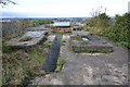
William's Shaft - Dolcoath Mine
The compressor base, the flywheel would have been sited here.
Image: © Ashley Dace
Taken: 24 Nov 2013
0.18 miles
3

William's Shaft - Dolcoath Mine
This is the William's Shaft winding house. A large Holman's transversing winder was sited here. A model was built by the company Image] in 1900. The shaft was very deep at 923 metres or so.
Image: © Ashley Dace
Taken: 24 Nov 2013
0.19 miles
4

William's Shaft - Dolcoath Mine
This is the William's Shaft winding house. A large Holman's transversing winder was sited here. A model was built by the company Image] in 1900. The shaft was very deep at 923 metres or so.
Image: © Ashley Dace
Taken: 24 Nov 2013
0.19 miles
5

Winding house, William's Shaft, Dolcoath Mine
This was one of the last deep shafts sunk on the Dolcoath Mine. In fact, the deepest shaft in the west of England, sunk in 1910 to open up Main Lode at depth. It passes through Brea and Main Lodes, respectively, at the 220 fm (1320 ft) and 490 fm (2940 ft) levels and reaches a depth of 550 fms or 3300 feet.
Inside the winding house was a unique traversing steam whim, or winder, which was made by the local foundry Holmans. Because of the depth of the shaft it was necessary to lay the steel winding rope on the drum in an equal fashion, and by moving the whole winding mechanism, this layered the rope accordingly. The shaft is, of course, capped, but a breather pipe in the cap allows - with the aid of a powerful torch - the water, which now occupies this shaft at water table level to be seen. Strange sounds from below are no doubt caused by the water.
Image: © Richard Bird
Taken: 7 Jul 2019
0.19 miles
6

William's Shaft - Dolcoath Mine
The remains of William's shaft, I was careful treading, its 923 metres deep!
Concrete capping is now buried by vegetation, however water can be heard clearly from the rusted pipe.
Image: © Ashley Dace
Taken: 24 Nov 2013
0.19 miles
7
William's Shaft - Dolcoath Mine
The compressor base at the once almighty Dolcoath. This is at William's shaft, the deepest hard rock shaft in the UK? Boubly mine is 1.1 km deep, this is 923 metres.
Image: © Ashley Dace
Taken: 24 Nov 2013
0.19 miles


10
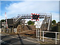
Railway footbridge at Pengegon level crossing
Image: © Rod Allday
Taken: 22 Oct 2010
0.24 miles