IMAGES TAKEN NEAR TO
Pendarves Road, CAMBORNE, TR14 7QG
Introduction
This page details the photographs taken nearby to Pendarves Road, TR14 7QG by members of the Geograph project.
The Geograph project started in 2005 with the aim of publishing, organising and preserving representative images for every square kilometre of Great Britain, Ireland and the Isle of Man.

There are currently over 7.5m images from over14,400 individuals and you can help contribute to the project by visiting https://www.geograph.org.uk
Image Map
Images are licensed for reuse under creativecommons.org/licenses/by-sa/2.0
Notes
- Clicking on the map will re-center to the selected point.
- The higher the marker number, the further away the image location is from the centre of the postcode.
Image Listing (8 Images Found)
Images are licensed for reuse under creativecommons.org/licenses/by-sa/2.0
Image
Details
Distance
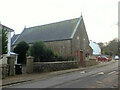
1
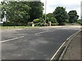
Modern boundary stone Camborne and Redruth district
Image: © Ben Chmark
Taken: 24 Jun 2024
0.08 miles
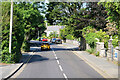
6
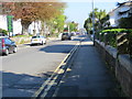
Basset Road in Camborne
Looking northward.
Image: © Peter Wood
Taken: 2 May 2017
0.24 miles
8
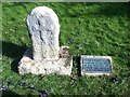
Cross
Milestone Society National ID: CWKE_CAM05
National Survey of Wayside Features by The Milestone Society
Image: © Paul Barnett
Taken: 27 Feb 2016
0.25 miles