IMAGES TAKEN NEAR TO
Sanctuary Close, CAMBORNE, TR14 7PT
Introduction
This page details the photographs taken nearby to Sanctuary Close, TR14 7PT by members of the Geograph project.
The Geograph project started in 2005 with the aim of publishing, organising and preserving representative images for every square kilometre of Great Britain, Ireland and the Isle of Man.

There are currently over 7.5m images from over14,400 individuals and you can help contribute to the project by visiting https://www.geograph.org.uk
Image Map (Loading...)


Getting Data...Please wait
Leaflet Map data © OpenStreetMap
Images are licensed for reuse under creativecommons.org/licenses/by-sa/2.0
Notes
- Clicking on the map will re-center to the selected point.
- The higher the marker number, the further away the image location is from the centre of the postcode.
Image Listing (18 Images Found)
Images are licensed for reuse under creativecommons.org/licenses/by-sa/2.0
Image
Details
Distance
1
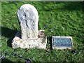
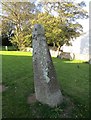
Cross
Milestone Society National ID: CWKE_CAM05
National Survey of Wayside Features by The Milestone Society
Image: © Paul Barnett
Taken: 27 Feb 2016
0.06 miles

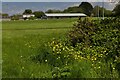
4
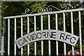
Gate at Camborne Rugby Club
Metal gate at Camborne Rugby Club.
Image: © Elizabeth Scott
Taken: 12 May 2023
0.18 miles
5

The Spinney - a peaceful rest area behind Camborne Parish Church
A 'Doorstep Green' project 'designed by the community for the community with the assistance of local children and artists based in Cornwall'.
Image: © Rod Allday
Taken: 22 Oct 2008
0.20 miles
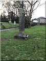
6

Two ancient crosses in the grounds of Camborne Parish Church
Image: © Rod Allday
Taken: 22 Oct 2008
0.21 miles
7
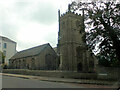
St Martin and St Meriadoc
National ID
CWKE_CAM02
Image: © Paul Barnett
Taken: 28 Sep 2014
0.21 miles
8
Old Wayside Cross
Connor Downs Cross, a wayside cross - moved, with old head & shaft. Set on the west side of the tower in the churchyard. Camborne parish. Langdon WC No. 12. Grade II Listed https://historicengland.org.uk/listing/the-list/list-entry/1328138. See also http://www.flickr.com/photos/ocifant/2837310246.
Milestone Society National ID: CWKE_CAM02
Image: © L Nott
Taken: 19 Sep 2019
0.22 miles
9
Ancient cross in St Martin and St Meriadoc churchyard
There is a small slate plaque cemented to the base and incised as follows: 'This ancient Cornish cross was found at Crane, Camborne'. This cross was first recorded by the antiquarian, Borlase, in 1750, when it stood in the grounds of St Ia's chapel at Troon, 2.25km south east of Camborne church. By 1896 the cross had been moved to Crane, 0.25km south west of Camborne church, where it was in use as part of a well head. The cross was then removed from Crane and erected in Camborne churchyard, in a cross-base which was already in the churchyard. It has been suggested that this cross-base is possibly part of the original churchyard cross, and may be connected with a cross-head which is mounted on the east wall of the church.
Milestone Society National ID: CWKE_CAM01
Image: © Paul Barnett
Taken: 18 Jan 2023
0.22 miles
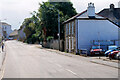
10
View to Camborne Rugby Club
View across the rugby field to the clubhouse.
Image: © Elizabeth Scott
Taken: 12 May 2023
0.22 miles