
IMAGES TAKEN NEAR TO
Park Holly, CAMBORNE, TR14 7NQ
Introduction
This page details the photographs taken nearby to Park Holly, TR14 7NQ by members of the Geograph project.
The Geograph project started in 2005 with the aim of publishing, organising and preserving representative images for every square kilometre of Great Britain, Ireland and the Isle of Man.

There are currently over 7.5m images from over14,400 individuals and you can help contribute to the project by visiting https://www.geograph.org.uk
Image Map
Images are licensed for reuse under creativecommons.org/licenses/by-sa/2.0
Notes
- Clicking on the map will re-center to the selected point.
- The higher the marker number, the further away the image location is from the centre of the postcode.
Image Listing (16 Images Found)
Images are licensed for reuse under creativecommons.org/licenses/by-sa/2.0
Image
Details
Distance
2
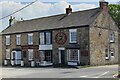
The Cornish Choughs
The Cornish Choughs pub is Grade II listed.
Image: © Elizabeth Scott
Taken: 12 May 2023
0.13 miles
4
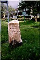
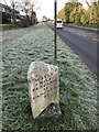
Old Milestone by the A3047 in Camborne - west face
Carved stone post by the A3047 (was A30), in parish of CAMBORNE (KERRIER District), Treswithian Road, on wide cut grass verge, on South side of road. Hayle facets, erected by the Hayle Bridge Causeway turnpike trust in the 19th century.
Inscription reads:-
: HAYLE / 6 MILES / PENZANCE / 13 / LAND'S END / 25 : : CAMBORNE / 1 MILE / REDRUTH / 5 / TRURO / 15 :
Grade II Listed. List Entry Number: 1142643
https://historicengland.org.uk/listing/the-list/list-entry/1142643
Milestone Society National ID: CW_PZCA13.
Image: © Ian Thompson
Taken: 10 Dec 2017
0.17 miles
6
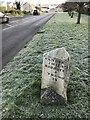
Old Milestone by the A3047 in Camborne - west face
Carved stone post by the A3047 (was A30), in parish of CAMBORNE (KERRIER District), Treswithian Road, on wide cut grass verge, on South side of road. Hayle facets, erected by the Hayle Bridge Causeway turnpike trust in the 19th century.
Inscription reads:-
: HAYLE / 6 MILES / PENZANCE / 13 / LAND'S END / 25 : : CAMBORNE / 1 MILE / REDRUTH / 5 / TRURO / 15
Grade II listed.
List Entry Number: 1142643
Milestone Society National ID: CW_PZCA13.
Image: © Paul Barnett
Taken: 16 Dec 2022
0.17 miles
7
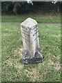
Old Milestone by A3047 (former A30), Treswithian Road
The Milestone is located on the wide cut grass verge on the South of the road. Parish of Camborne (Kerrier District). Carved stone post, Hayle facets design, erected by the Hayle Bridge Causeway turnpike trust in the 19th Century, back right edge broken off. An earlier photograph can be found here: https://www.geograph.org.uk/photo/5623497
Inscription reads:-
HAYLE / 6 MILES / PENZANCE / 13 / LANDS END / 25 : : CAMBOR(NE) / 1 MILE / REDRUTH / 5 / TRURO / 15
Grade II listed. List Entry Number: 1142643 https://historicengland.org.uk/listing/the-list/list-entry/1142643
Milestone Society National ID: CW_PZCA13
Image: © Paul Barnett
Taken: 11 Jul 2023
0.18 miles
8
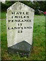
Old Milestone by the A3047 in Camborne - east face
Carved stone post by the A3047 (was A30), in parish of CAMBORNE (KERRIER District), Treswithian Road, on wide cut grass verge, on South side of road. Hayle facets, erected by the Hayle Bridge Causeway turnpike trust in the 19th century.
Inscription reads:-
: HAYLE / 6 MILES / PENZANCE / 13 / LAND'S END / 25 : : CAMBORNE / 1 MILE / REDRUTH / 5 / TRURO / 15 :
Grade II listed.
List Entry Number: 1142643
https://historicengland.org.uk/listing/the-list/list-entry/1142643
Milestone Society National ID: CW_PZCA13.
Image: © Rosy Hanns
Taken: 5 Jul 2019
0.18 miles
9
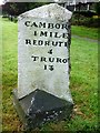
Old Milestone by the A3047 in Camborne - west face
Carved stone post by the A3047 (was A30), in parish of CAMBORNE (KERRIER District), Treswithian Road, on wide cut grass verge, on South side of road. Hayle facets, erected by the Hayle Bridge Causeway turnpike trust in the 19th century.
Inscription reads:-
: HAYLE / 6 MILES / PENZANCE / 13 / LAND'S END / 25 : : CAMBORNE / 1 MILE / REDRUTH / 5 / TRURO / 15 :
Grade II listed.
List Entry Number: 1142643
https://historicengland.org.uk/listing/the-list/list-entry/1142643
Milestone Society National ID: CW_PZCA13.
Image: © Rosy Hanns
Taken: 5 Jul 2019
0.18 miles
10
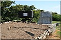
Welcome to Camborne
This welcome sign is on the main road into Camborne from the junction with the A30. It features a mine truck which was used in South Crofty Mine, the last tin mine to be worked in Europe. The flower bed looks like it is being readied for Summer planting.
Image: © Tony Atkin
Taken: 17 Jun 2006
0.19 miles