IMAGES TAKEN NEAR TO
Puggis Hill, CAMBORNE, TR14 0BL
Introduction
This page details the photographs taken nearby to Puggis Hill, TR14 0BL by members of the Geograph project.
The Geograph project started in 2005 with the aim of publishing, organising and preserving representative images for every square kilometre of Great Britain, Ireland and the Isle of Man.

There are currently over 7.5m images from over14,400 individuals and you can help contribute to the project by visiting https://www.geograph.org.uk
Image Map (Loading...)


Getting Data...Please wait
Leaflet Map data © OpenStreetMap
Images are licensed for reuse under creativecommons.org/licenses/by-sa/2.0
Notes
- Clicking on the map will re-center to the selected point.
- The higher the marker number, the further away the image location is from the centre of the postcode.
Image Listing (13 Images Found)
Images are licensed for reuse under creativecommons.org/licenses/by-sa/2.0
Image
Details
Distance
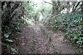
1
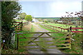
Track at Reskadinnick
This track of Puggis Hill leads to a farm. The bridleway to Coombe is further down the road to our right. It looks bright enough but there was a strong wind and ten minutes later it was raining. Ten minutes later again it had stopped.
Image: © Graham Horn
Taken: 19 Oct 2011
0.05 miles
2
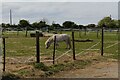
Miniature horse
As I walked down Puggis Hill I saw this miniature horse grazing in the field.
Image: © Elizabeth Scott
Taken: 2 May 2023
0.06 miles
3
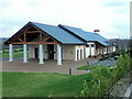
Chapel of Rest at Treswithian Downs Crematorium
Image: © Paul Barnett
Taken: Unknown
0.12 miles
5
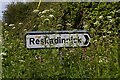
Direction sign to Reskadinnick
The res part of the place-name is probably the Cornish word for ford.
Image: © Elizabeth Scott
Taken: 2 May 2023
0.16 miles
6
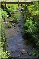
Stream at Reskadinnick
The stream at Reskadinnick.
Image: © Elizabeth Scott
Taken: 2 May 2023
0.16 miles
7
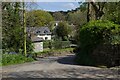
Houses at Reskadinnick
Looking down Puggis Hill to houses at Reskadinnick.
Image: © Elizabeth Scott
Taken: 2 May 2023
0.17 miles
8
Treswithian Downs crematorium
This must be a relatively new crematorium as it does not appear on the current version of the 1:25,000 map. It probably serves Camborne.
Image: © Graham Horn
Taken: 19 Oct 2011
0.19 miles
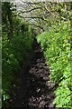
9
Bridleway towards Reskadinnick
This bridleway is a narrow sunken lane rising gradually in this direction. I'll bet it acts as a main watercourse when rains come.
Image: © Graham Horn
Taken: 19 Oct 2011
0.22 miles
10
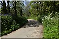
Bend in the road at Reskadinnick
Spring flowers lining the road.
Image: © Elizabeth Scott
Taken: 2 May 2023
0.22 miles