IMAGES TAKEN NEAR TO
Trevethlyn, CAMBORNE, TR14 0BG
Introduction
This page details the photographs taken nearby to Trevethlyn, TR14 0BG by members of the Geograph project.
The Geograph project started in 2005 with the aim of publishing, organising and preserving representative images for every square kilometre of Great Britain, Ireland and the Isle of Man.

There are currently over 7.5m images from over14,400 individuals and you can help contribute to the project by visiting https://www.geograph.org.uk
Image Map (Loading...)


Getting Data...Please wait
Leaflet Map data © OpenStreetMap
Images are licensed for reuse under creativecommons.org/licenses/by-sa/2.0
Notes
- Clicking on the map will re-center to the selected point.
- The higher the marker number, the further away the image location is from the centre of the postcode.
Image Listing (12 Images Found)
Images are licensed for reuse under creativecommons.org/licenses/by-sa/2.0
Image
Details
Distance
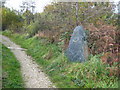
1
Footpath into Tuckingmill Valley Park
Tuckingmill Valley has been transformed from the most visible derelict land site in West Cornwall into an award winning park. The park has a bespoke skate park, walking trails, play facilities, public toilet and creative art installations set within a rich mosaic of habitats http://www.cornwall.gov.uk/default.aspx?page=21701.
Image: © Rod Allday
Taken: 22 Oct 2010
0.08 miles
2
Entrance to Tuckingmill Valley Park
The Red River valley below Tuckingmill was once derelict industrial land but is now parkland with recreational facilities and diverse fauna and flora.
Image: © Tony Atkin
Taken: 30 Dec 2005
0.08 miles
3
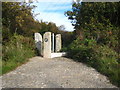
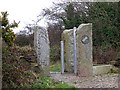
Sculpture in Tuckingmill Valley Park
A piece of raw slate engraved with a picture of a sailing ship and the names of places all over the world to which Cornish miners emigrated.
Image: © Rod Allday
Taken: 22 Oct 2010
0.09 miles
4

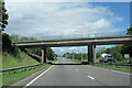
Overbridge west of junction for Camborne
Part of slip road can be seen to left
Image: © John Firth
Taken: 13 Jun 2014
0.11 miles
5
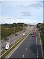
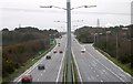
The A30 at Roskear
Looking eastwards from the bridge by Tuckingmill Valley Park. Owing to resurfacing works a contraflow system is in operation ahead.
Image: © Rod Allday
Taken: 22 Oct 2010
0.12 miles
6
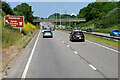
The A30 east near exit for A3047 for Pool
Image: © Roy Hughes
Taken: 1 Jul 2022
0.12 miles
7
The A30
Looking east towards Poole junction.
Image: © Tony Atkin
Taken: 30 Dec 2005
0.17 miles
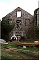
9
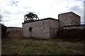
New Roskear Mine, Camborne
This was latterly an alternative access for South Crofty and closed with that mine. The derelict winding engine house (not visible) contained the incomplete remains of a duplex steam winding engine. Built 1897 and moved here in 1924. In 2005 the remains were removed to South Crofty as part of a World heritage bid project and are now preserved on the Dolcoath site - Image I have no idea what this site now looks like.
Image: © Chris Allen
Taken: 6 Apr 2000
0.22 miles
10
New Roskear Mine
Winding engine house with remains of steam winding engine - now removed.
Image: © Chris Allen
Taken: 6 Apr 2000
0.23 miles