IMAGES TAKEN NEAR TO
West Seton, CAMBORNE, TR14 0AH
Introduction
This page details the photographs taken nearby to West Seton, TR14 0AH by members of the Geograph project.
The Geograph project started in 2005 with the aim of publishing, organising and preserving representative images for every square kilometre of Great Britain, Ireland and the Isle of Man.

There are currently over 7.5m images from over14,400 individuals and you can help contribute to the project by visiting https://www.geograph.org.uk
Image Map (Loading...)


Getting Data...Please wait
Leaflet Map data © OpenStreetMap
Images are licensed for reuse under creativecommons.org/licenses/by-sa/2.0
Notes
- Clicking on the map will re-center to the selected point.
- The higher the marker number, the further away the image location is from the centre of the postcode.
Image Listing (10 Images Found)
Images are licensed for reuse under creativecommons.org/licenses/by-sa/2.0
Image
Details
Distance
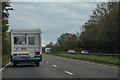
1
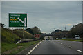
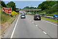
Camborne : A30
The A30 heading through the Camborne parish.
Image: © Lewis Clarke
Taken: 22 Oct 2019
0.15 miles
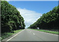
2
Camborne : A30
The A30 heading through the Camborne parish.
Image: © Lewis Clarke
Taken: 22 Oct 2019
0.18 miles
3
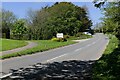
Road junction near Duchy College
The Tehidy Road goes uphill and the road and the lane to Duchy College branch off on the left.
Image: © Elizabeth Scott
Taken: 1 May 2023
0.19 miles
4

Duchy College roadside sign
Duchy College uses the Cornish heraldic shield with fifteen golden bezants on a black background.
Image: © Elizabeth Scott
Taken: 1 May 2023
0.20 miles
7
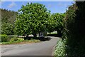
Horse chestnut trees at Duchy College
Horse chestnut trees along the lane at Duchy College.
Image: © Elizabeth Scott
Taken: 1 May 2023
0.22 miles
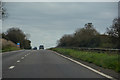
8
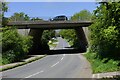
Bridge over Tehidy Road
The A30 passes over the Tehidy Road here.
Image: © Elizabeth Scott
Taken: 1 May 2023
0.22 miles
9
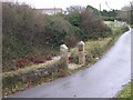
In Commemoration of an Airplane Crash
This used to be the location of a Methodist Chapel which in 1942 was being used as a warehouse when an RAF Bristol Beaufort on route to Malta crashed here with the loss of all four crew. The plaque on the gatepost commemorates these airmen.
Image: © Tony Atkin
Taken: 30 Dec 2005
0.22 miles
10
Camborne : A30
The A30 heading through the Camborne parish.
Image: © Lewis Clarke
Taken: 22 Oct 2019
0.25 miles