IMAGES TAKEN NEAR TO
Trevean Road, TRURO, TR1 3QP
Introduction
This page details the photographs taken nearby to Trevean Road, TR1 3QP by members of the Geograph project.
The Geograph project started in 2005 with the aim of publishing, organising and preserving representative images for every square kilometre of Great Britain, Ireland and the Isle of Man.

There are currently over 7.5m images from over14,400 individuals and you can help contribute to the project by visiting https://www.geograph.org.uk
Image Map
Images are licensed for reuse under creativecommons.org/licenses/by-sa/2.0
Notes
- Clicking on the map will re-center to the selected point.
- The higher the marker number, the further away the image location is from the centre of the postcode.
Image Listing (13 Images Found)
Images are licensed for reuse under creativecommons.org/licenses/by-sa/2.0
Image
Details
Distance
2
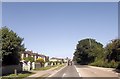
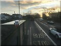
The A39
Traffic in the suburbs of Truro.
Image: © Robert Ashby
Taken: 21 Aug 2014
0.08 miles
4
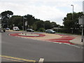
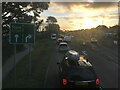
?Magic ? Roundabout, Higher Town, Truro
Image: © Richard Rogerson
Taken: 23 Aug 2011
0.12 miles
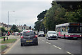
7
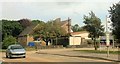
All Saints church, Highertown
Near the hospital
Image: © Paul Barnett
Taken: 29 Oct 2015
0.13 miles
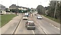
8
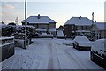
Junction of Newbridge Lane and Tresawls Avenue, Truro
After the snow fall of February 2009.
Image: © Fred James
Taken: 3 Feb 2009
0.14 miles
9
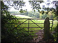
Small field at Treliske
Looking down towards Coosebean in the Kenwyn valley.
Image: © Rod Allday
Taken: 9 Oct 2009
0.14 miles
10
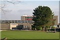
The Old Richard Lander School, Truro
Richard Lander School moved into new premises in September 2006 but in December 2005 when this was taken these buildings were still in use. The school is for 11 to 16 year old pupils and specialises in technology. The photograph looks over playing fields to the rear of the school. Image
Image: © Tony Atkin
Taken: 10 Dec 2005
0.17 miles