IMAGES TAKEN NEAR TO
Cornish Crescent, TRURO, TR1 3PF
Introduction
This page details the photographs taken nearby to Cornish Crescent, TR1 3PF by members of the Geograph project.
The Geograph project started in 2005 with the aim of publishing, organising and preserving representative images for every square kilometre of Great Britain, Ireland and the Isle of Man.

There are currently over 7.5m images from over14,400 individuals and you can help contribute to the project by visiting https://www.geograph.org.uk
Image Map
Images are licensed for reuse under creativecommons.org/licenses/by-sa/2.0
Notes
- Clicking on the map will re-center to the selected point.
- The higher the marker number, the further away the image location is from the centre of the postcode.
Image Listing (37 Images Found)
Images are licensed for reuse under creativecommons.org/licenses/by-sa/2.0
Image
Details
Distance
2
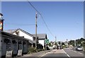
Junction of Penwethers Lane and Highertown
Image: © Roger Templeman
Taken: 12 Nov 2011
0.14 miles
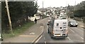
3
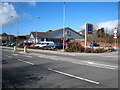
Aldi supermarket on the corner of Highertown and Dobbs Lane
Image: © Rod Allday
Taken: 26 Feb 2010
0.15 miles
4
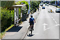
Bus Stop on the A390, Highertown
A cyclist passing the Penwortham Lane bus stop.
Image: © David Dixon
Taken: 4 Jun 2023
0.15 miles
5

Electric vehicle chargepoint, County Arms, Highertown, Truro
In the hotel car park.
Image: © David Hawgood
Taken: 11 Apr 2016
0.15 miles

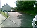
8
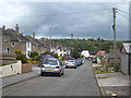
Sunningdale Truro
A residential road of 1930s houses on the west side of the city.
Image: © Rod Allday
Taken: 8 Jul 2011
0.16 miles
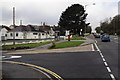
9
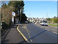
Bus stop and bus, Highertown, Truro
The road is the A390. Beyond the bus stop on the left is the County Arms public house.
Image: © David Hawgood
Taken: 11 Apr 2016
0.16 miles