IMAGES TAKEN NEAR TO
Tre El Vern Close, TRURO, TR1 3NP
Introduction
This page details the photographs taken nearby to Tre El Vern Close, TR1 3NP by members of the Geograph project.
The Geograph project started in 2005 with the aim of publishing, organising and preserving representative images for every square kilometre of Great Britain, Ireland and the Isle of Man.

There are currently over 7.5m images from over14,400 individuals and you can help contribute to the project by visiting https://www.geograph.org.uk
Image Map
Images are licensed for reuse under creativecommons.org/licenses/by-sa/2.0
Notes
- Clicking on the map will re-center to the selected point.
- The higher the marker number, the further away the image location is from the centre of the postcode.
Image Listing (60 Images Found)
Images are licensed for reuse under creativecommons.org/licenses/by-sa/2.0
Image
Details
Distance

2
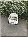
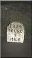
Old Milestone by the A390 in Highertown, Truro
Carved stone post by the A390, in parish of TRURO (CARRICK District), Highertown, West of roundabout, by bus stop, on North side of road. Truro stone, erected by the Truro turnpike trust in the 18th century.
Inscription reads:-
FROM / TRURO / 1 / MILE
Grade II Listed. List Entry Number:1280758 https://historicengland.org.uk/listing/the-list/list-entry/1280758
Milestone Society National ID: CW_TOAG01.
Image: © P Barnett
Taken: 21 Mar 2023
0.05 miles
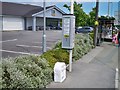
3
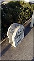
Benchmark on milestone, Highertown
Ordnance Survey rivet benchmark described on the Bench Mark Database at http://www.bench-marks.org.uk/bm40155
Image: © Roger Templeman
Taken: 12 Nov 2011
0.06 miles
4
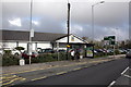
North side of Highertown at Aldi store
In the view, a bus stop and a milestone with an OS benchmark Image
Image: © Roger Templeman
Taken: 12 Nov 2011
0.06 miles
5
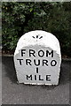
Old Milestone by the A390 in Highertown, Truro
Carved stone post by the A390, in parish of TRURO (CARRICK District), Highertown, West of roundabout, by bus stop, on North side of road. Truro stone, erected by the Truro turnpike trust in the 18th century.
Inscription reads:-
FROM
TRURO
1
MILE
Grade II Listed. List Entry Number:1280758
https://historicengland.org.uk/listing/the-list/list-entry/1280758
Milestone Society National ID: CW_TOAG01.
Image: © Ian Thompson
Taken: 1 Oct 1996
0.06 miles
6
Old Milestone by the A390 in Highertown, Truro
Carved stone post by the A390, in parish of TRURO (CARRICK District), Highertown, West of roundabout, by bus stop, on North side of road. Truro stone, erected by the Truro turnpike trust in the 18th century.
Inscription reads:-
FROM
TRURO
1
MILE
Grade II Listed. List Entry Number:1280758
Milestone Society National ID: CW_TOAG01.
Image: © Paul Barnett
Taken: 6 Jan 2023
0.06 miles
7
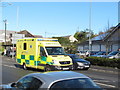
Emergency ambulance in traffic, Highertown, Truro
The ambulance has blue lights and headlamps flashing. Traffic on the A390 outside Aldi has pulled in on both sides of the road to let it through.
Image: © David Hawgood
Taken: 11 Apr 2016
0.06 miles
8
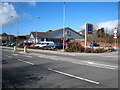
Aldi supermarket on the corner of Highertown and Dobbs Lane
Image: © Rod Allday
Taken: 26 Feb 2010
0.06 miles
10
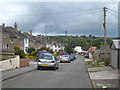
Sunningdale Truro
A residential road of 1930s houses on the west side of the city.
Image: © Rod Allday
Taken: 8 Jul 2011
0.07 miles