
IMAGES TAKEN NEAR TO
Wheal Golden Drive, TRURO, TR1 3FZ
Introduction
This page details the photographs taken nearby to Wheal Golden Drive, TR1 3FZ by members of the Geograph project.
The Geograph project started in 2005 with the aim of publishing, organising and preserving representative images for every square kilometre of Great Britain, Ireland and the Isle of Man.

There are currently over 7.5m images from over14,400 individuals and you can help contribute to the project by visiting https://www.geograph.org.uk
Image Map
Images are licensed for reuse under creativecommons.org/licenses/by-sa/2.0
Notes
- Clicking on the map will re-center to the selected point.
- The higher the marker number, the further away the image location is from the centre of the postcode.
Image Listing (168 Images Found)
Images are licensed for reuse under creativecommons.org/licenses/by-sa/2.0
Image
Details
Distance
1

Old County Hall
The old county hall, on Station Road, replaced by Image] in the 1960s, but still in use as council offices.
Image: © David Dixon
Taken: 28 Jul 2010
0.03 miles
2

Old County Hall
The old county hall, on Station Road, replaced by Image] in the 1960s, but still in use as council offices.
Image: © David Dixon
Taken: 28 Jul 2010
0.03 miles
3

Old County Hall Truro
Still County Council offices but superseded as the county hall when the new one was built in the early 1960s.
Image: © Rod Allday
Taken: 13 Jul 2008
0.04 miles


6

Benchmark on the Fire & Rescue Service HQ
Ordnance Survey rivet benchmark described on the Bench Mark Database at http://www.bench-marks.org.uk/bm40157
Image: © Roger Templeman
Taken: 12 Nov 2011
0.04 miles
7
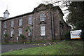
Fire & Rescue Service HQ, Station Road
On the side of the building is an OS benchmark Image
Image: © Roger Templeman
Taken: 12 Nov 2011
0.04 miles
8

Ancient and modern at Truro
A 21st century class 800 IET train being signalled by a Victorian era technology semaphore signal. The train is on a Paddington to Penzance service. The Falmouth branch line runs into the bay platform on the left. The branch is not totally self-contained, as trains using it run for about a kilometre on the main line. For this reason, a catch-point is used to prevent errant trains running onto the main line from the bay platform. Here, the catch-point has been set to protect the main line. See also Image
Image: © John Lucas
Taken: 9 Feb 2023
0.05 miles
9

Three semaphore signals, Truro
Viewed from the western end of platforms 1 and 2.
Image: © Jaggery
Taken: 16 Oct 2015
0.05 miles
10

Leaving Truro
Mainline train to Penzance, crossing the point where the Falmouth Branch Line briefly shares the main line for less than half a mile. The lines will branch again at Penwithers Junction (SW810444).
The following information was provided by John Webb:
Note on the right signal T26 installed in connection with the recent improvements at Penryn to give a passing loop. T26 allows a branch train to terminate on the Up platform and leave again for Falmouth without being shunted to platform 1. Note too the robust modern structure supporting it compared to the older design of the further signal!
Image: © David Dixon
Taken: 28 Jul 2010
0.05 miles