IMAGES TAKEN NEAR TO
Kenwyn Park, TRURO, TR1 3DZ
Introduction
This page details the photographs taken nearby to Kenwyn Park, TR1 3DZ by members of the Geograph project.
The Geograph project started in 2005 with the aim of publishing, organising and preserving representative images for every square kilometre of Great Britain, Ireland and the Isle of Man.

There are currently over 7.5m images from over14,400 individuals and you can help contribute to the project by visiting https://www.geograph.org.uk
Image Map
Images are licensed for reuse under creativecommons.org/licenses/by-sa/2.0
Notes
- Clicking on the map will re-center to the selected point.
- The higher the marker number, the further away the image location is from the centre of the postcode.
Image Listing (9 Images Found)
Images are licensed for reuse under creativecommons.org/licenses/by-sa/2.0
Image
Details
Distance
1
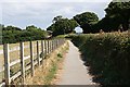
The Beynon Way
This is a footpath and cycleway built alongside the road between Shortlanesend and Truro.
Image: © Tony Atkin
Taken: 23 Jul 2006
0.06 miles
2
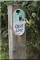
Quiet lane designation sign
The lane from Kenwyn to New Mill is designated a Quiet Lane.
Image: © Elizabeth Scott
Taken: 12 Sep 2013
0.09 miles
3
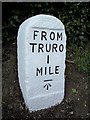
Old Milestone by the B3284
Carved stone post by the B3284, in parish of KENWYN (CARRICK District), Kenwyn, top of hill; opposite City of Truro sign, by the road, on West side of road. Truro stone, erected by the Truro turnpike trust in the 18th century.
Inscription reads:-
FROM
TRURO
1
MILE
Carved benchmark on front face.
Grade II Listed. List Entry Number:1396423
https://historicengland.org.uk/listing/the-list/list-entry/1396423
Milestone Society National ID: CW_TOPP01.
Image: © Ian Thompson
Taken: 1 Oct 1996
0.10 miles
4
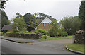
Houses at Pencarrick
Houses at Pencarrick, just off the lane to New Mill.
Image: © Elizabeth Scott
Taken: 12 Sep 2013
0.13 miles
5
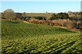
Pasture, Kenwyn
About two hundred metres of public footpath comes to a dead-end in the woodland to the right of picture.
Image: © Andrew Smith
Taken: 5 Mar 2022
0.21 miles
7
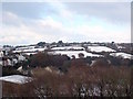
Snow covered fields in the Kenwyn valley
Seen from the top deck of Sainsbury's car park, looking across the roofs of the warehouses at Truro station with houses in Dobbs lane on the left of the picture.
Image: © Rod Allday
Taken: 27 Nov 2010
0.24 miles
8
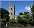
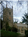
Kenwyn Church
The tower is almost all that is visible from the road. It is the oldest part of the church and dates back to the 15th century.
Image: © Tony Atkin
Taken: 23 Jul 2006
0.25 miles