IMAGES TAKEN NEAR TO
Chapel Hill, TRURO, TR1 3BW
Introduction
This page details the photographs taken nearby to Chapel Hill, TR1 3BW by members of the Geograph project.
The Geograph project started in 2005 with the aim of publishing, organising and preserving representative images for every square kilometre of Great Britain, Ireland and the Isle of Man.

There are currently over 7.5m images from over14,400 individuals and you can help contribute to the project by visiting https://www.geograph.org.uk
Image Map (129 Images)


Leaflet Map data © OpenStreetMap
Images are licensed for reuse under creativecommons.org/licenses/by-sa/2.0
Notes
- Clicking on the map will re-center to the selected point.
- The higher the marker number, the further away the image location is from the centre of the postcode.
Image Listing (129 Images Found)
Images are licensed for reuse under creativecommons.org/licenses/by-sa/2.0
Image
Details
Distance
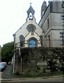
2
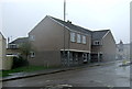
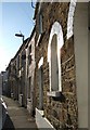
Truro Baptist church
Next to Bosvigo School
Image: © Paul Barnett
Taken: 30 Oct 2015
0.05 miles
4
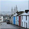
Chapel Hill - and view towards Truro Cathedral
Image: © Ian Hawfinch
Taken: 17 Feb 2023
0.06 miles
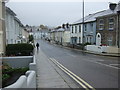
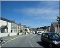
5
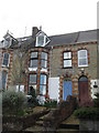
Bosvigo Road, Truro
A terrace in the western part of the city not far from the station.
Image: © Derek Harper
Taken: 6 Sep 2007
0.08 miles
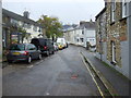
6
The Rowan Tree Bed and Breakfast, Parkvedras Terrace, Truro
Image: © Richard Rogerson
Taken: 14 Apr 2009
0.09 miles