IMAGES TAKEN NEAR TO
Hendra Lane, HELSTON, TR13 9TU
Introduction
This page details the photographs taken nearby to Hendra Lane, TR13 9TU by members of the Geograph project.
The Geograph project started in 2005 with the aim of publishing, organising and preserving representative images for every square kilometre of Great Britain, Ireland and the Isle of Man.

There are currently over 7.5m images from over14,400 individuals and you can help contribute to the project by visiting https://www.geograph.org.uk
Image Map
Images are licensed for reuse under creativecommons.org/licenses/by-sa/2.0
Notes
- Clicking on the map will re-center to the selected point.
- The higher the marker number, the further away the image location is from the centre of the postcode.
Image Listing (38 Images Found)
Images are licensed for reuse under creativecommons.org/licenses/by-sa/2.0
Image
Details
Distance
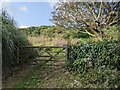
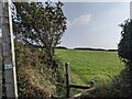
2
Hendra Lane passes entrance to Seacroft Barton
Image: © Stuart Logan
Taken: 12 Oct 2012
0.06 miles
3
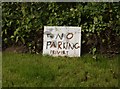
No parking - privert
OK we got the message, even if the spellin' is a bit suspect. Delibrert?
Image: © Graham Horn
Taken: 15 Jun 2006
0.06 miles
6
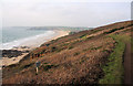
Coastal path at Lesceave
The wide expanse of Praa Sands extends westwards. The sign warns walkers of the unstable cliff.
Image: © Bob Jones
Taken: 31 Dec 2008
0.10 miles
7
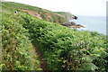
The South West Coast Path on Rinsey West Cliff
A gentle climb towards Rinsey Head.
Image: © Bill Boaden
Taken: 7 Jul 2014
0.10 miles
8
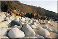
Boulders at Lesceave Por
One black boulder nestles amongst the rounded granite rocks at the eastern end of Praa Sands.
Image: © Bob Jones
Taken: 31 Dec 2008
0.11 miles
9
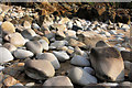
Boulders at Lesceave Por
Huge rounded granite boulders lie at the head of the beach.
Image: © Bob Jones
Taken: 31 Dec 2008
0.12 miles
10
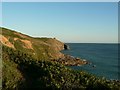
Lesceave Cliff
Seen from the path along the top of the cliff, looking toward Rinsey Head.
Image: © Rich Tea
Taken: 2 Aug 2006
0.13 miles